Filter: Subject of recreation areas
Filter: Subject of streets
Filter: Subject of recreation areas
Filter: Subject of streets
| Date: | 1890 |
|---|---|
| Description: | The Madison water tower and farmers' market as seen through the stone gateway at the East Washington Avenue entrance to the Capitol Park. The building on t... |
| Date: | |
|---|---|
| Description: | Elevated view looking down West Washington Avenue at the Congregational Church (on the left) and the Grace Episcopal Church, two of the era's large and lav... |

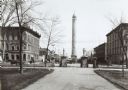
| Date: | 1890 |
|---|---|
| Description: | Bird's-eye map of Ashland, viewed from Lake Superior, with insets of Prentice Park and Fishery. Population 16,000. Increase in Ten Years, 11,000. |
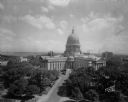
| Date: | 08 24 1945 |
|---|---|
| Description: | Elevated view of the Wisconsin State Capitol from the roof of the Loraine Hotel. |
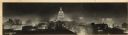
| Date: | 1940 |
|---|---|
| Description: | Panorama view, elevated, of the Wisconsin State Capitol at night from the roof of a building on Monona Avenue. The First National Bank and the Belmont Hote... |
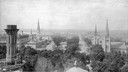
| Date: | |
|---|---|
| Description: | Elevated view from the Wisconsin State Capitol dome toward West Washington Avenue. The Park Hotel is on the left. The four church steeples that can be iden... |
| Date: | 1900 |
|---|---|
| Description: | Pedestrians and a horse and cart at the intersection of Main Street and Monona Avenue (South Wisconsin Avenue until December 1, 1877; Martin Luther King J... |
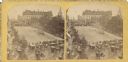
| Date: | 07 04 1876 |
|---|---|
| Description: | Stereograph of view of procession, military company and citizens at Great Centennial Day at the Capitol Square. Scene at Main and Carroll Streets showing t... |

| Date: | 2007 |
|---|---|
| Description: | This map of Cedarbug is a bird's-eye map with 8 inset views and an index. The map is a print out of the original map dated 1892 held at the Cedarburg Cultu... |

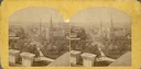
| Date: | 1891 |
|---|---|
| Description: | Bird's-eye view of Eau Claire. |

| Date: | 1896 |
|---|---|
| Description: | Bird's-eye map of Fond du Lac, looking north west, with two insets of the P.H. Stamm residence, and the Proposed Lakeside Park. thirty-five locations ident... |

| Date: | 05 18 1934 |
|---|---|
| Description: | Elevated view of East Washington Avenue taken from an upper level of the Wisconsin State Capitol. Shows the First National Bank Building, American Exchange... |
| Date: | 07 24 1931 |
|---|---|
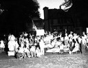
| Description: | Children in costume with go cars from Brittingham Park waiting to participate in Lantern parade. |

| Date: | 01 29 1931 |
|---|---|
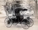
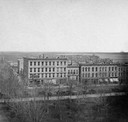
| Description: | Elevated view of Wisconsin Foundry and Machine Company road construction equipment, featuring a new portable rock crushing plant, on display at the Wiscons... |
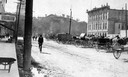
| Date: | 1860 |
|---|---|
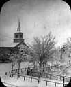
| Description: | Elevated wintertime view of the intersection of South Carroll and West Main Streets, showing the First Baptist Church constructed in 1854, the wooden fence... |
| Date: | |
|---|---|
| Description: | Slightly elevated view of the stone gateway at the intersection of Pinckney, Main, and King Streets and the iron fence that surrounded the entire Capitol P... |
| Date: | 1873 |
|---|---|
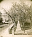
| Description: | Elevated view of South Pinckney Street from the Wisconsin State Capitol, with East Washington Avenue to the left and Lake Monona on the distant right. The ... |
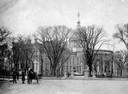
| Date: | |
|---|---|
| Description: | View of the North Wing of the third Wisconsin State Capitol in the background, the Capitol Park, and farm wagons on East Washington Avenue on market day. T... |

| Date: | 1900 |
|---|---|
| Description: | The State Street approach to the Wisconsin State Capitol at the turn of the century. Electric poles and street railroad wires are in the foreground. In the... |
If you didn't find the material you searched for, our Library Reference Staff can help.
Call our reference desk at 608-264-6535 or email us at: