 Filter: Subject of resorts
Filter: Subject of rivers
Filter: Subject of resorts
Filter: Subject of rivers
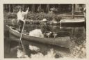
| Date: | 1928 |
|---|---|
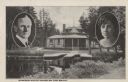
| Description: | President Calvin Coolidge fishing at Cedar Island Lodge, rustic lodge of Henry C. Pierce, 35 miles from Superior, Wisconsin, on the Brule River. This lodge... |

| Date: | 1886 |
|---|---|
| Description: | Bird's-eye map of Baraboo with inset of Devil's Lake, the south and east sides of the commercial square, the First National Bank, and the Warren House hote... |

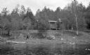
| Date: | |
|---|---|
| Description: | Ground around lodge covered in mud and ice, some from the frozen river in the background. There is a large birdhouse on a pole on the left. |
| Date: | |
|---|---|
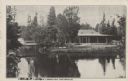
| Description: | View along shoreline through trees of a wet boathouse at The Morey Resort. Caption reads: "Boat House, The Morey Resort, Eagle River, Wis." |
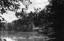
| Date: | |
|---|---|
| Description: | View from water of a man wearing a hat and boots walking along the shoreline. A cabin is located up on the bank. |
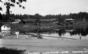
| Date: | 1935 |
|---|---|
| Description: | Variety of buildings reflected in Teal Lake. A wooden rowboat is tied to a pier on the lake. The Teal River is rushing over a nearby dam and along the dirt... |
| Date: | |
|---|---|
| Description: | Black and white postcard view of the President's Dining Lodge on the Brule River surrounded by trees. A bridge is on the left. Caption reads: "President's ... |
| Date: | 1926 |
|---|---|
| Description: | Black and white postcard view of Cedar Island Lodge, located on the Brule River, owned by Henry Clay Pierce, businessman and financier. It was dubbed the S... |
| Date: | |
|---|---|
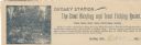
| Description: | Letterhead of Dudley Station, a hunting and trout fishing resort in Dudley, Wisconsin. On the left is an illustration of a fisherman holding a fishing pole... |

| Date: | 1958 |
|---|---|
| Description: | Includes images of Flambeau River State Forest and a description of, canoeing and recreational activities in, and general park and forest information about... |

| Date: | 1903 |
|---|---|
| Description: | A map of northern Wisconsin and Michigan showing the names and locations hunting and fishing resorts in the area, as well as location of Chicago and North ... |

| Date: | 1904 |
|---|---|
| Description: | A map that shows the location of the lakes and resorts in northeastern Wisconsin that were reachable by the Chicago and North Western Railway. Shown in the... |

| Date: | 1914 |
|---|---|
| Description: | Two maps of northern Wisconsin counties of Ashland, Barron, Bayfield, Chippewa, Douglas, Forest, Iron, Langlade, Lincoln, Oneida, Polk, Price, Sawyer, Tayl... |

| Date: | 1950 |
|---|---|
| Description: | This road map shows federal, state and county roads in Wisconsin, northern Illinois, northeastern Iowa, eastern Minnesota, and the western portion of Michi... |

| Date: | 1891 |
|---|---|
| Description: | A hand-colored map of Milwaukee County, Wisconsin that shows the township and range system, sections, towns, roads, railroads and rail stations, cities and... |

| Date: | 1915 |
|---|---|
| Description: | This 1915 map shows railroads, wagon roads, trails, creeks, rivers, lakes, and trout streams in Oneida and Lincoln counties within a 12 mile radius of Rhin... |
| Date: | 12 1900 |
|---|---|
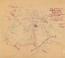
| Description: | This manuscript map from 1900 shows resorts, lakes, rivers and streams, roads, railroads, and telephone lines in northwest Vilas County, in the towns of Bo... |

| Date: | 1905 |
|---|---|
| Description: | This early 20th century map identifies the locations of the Divide Resort and Spider Lake Resort in Vilas County, Wisconsin. Also shown are trails, stage l... |

| Date: | 1941 |
|---|---|
| Description: | This 1941 map covers Washburn County, Wisconsin, as well as western Sawyer, eastern Burnett, and northeastern Polk counties. It shows the locations of tour... |

| Date: | 1955 |
|---|---|
| Description: | This 1950s tourist brochure features a map of Burnett County, Wisconsin, and northern Polk County which shows highways and roads, railroads, landmarks, and... |
If you didn't find the material you searched for, our Library Reference Staff can help.
Call our reference desk at 608-264-6535 or email us at: