 Filter: Subject of rivers
Filter: Subject of law
Filter: Subject of rivers
Filter: Subject of law

| Date: | 1885 |
|---|---|
| Description: | Bird's-eye map of Waupun on the Rock River. There is an inset at top center of "Althouse, Wheeler & Co., Windmills and Pumps." |

| Date: | 1942 |
|---|---|
| Description: | Warden Kramer and his assistant in a boat removing an illegal snag line from the Wolf River. |

| Date: | |
|---|---|
| Description: | Bird's-eye view of the north branch extension canal on the Susquehanna river, surrounded by smaller renderings of structures of interest around the town in... |

| Date: | 1958 |
|---|---|
| Description: | Supreme Court Justice William O. Douglas during a canoe trip with conservationist Sigurd F. Olson. He is sitting with his hat in hand beside a canoe pulled... |
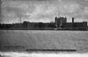
| Date: | 1921 |
|---|---|
| Description: | View across river toward the exterior of the prison, with the central tower and wings. A boat sits at the dock on the far shoreline, and a large smokestack... |

| Date: | |
|---|---|
| Description: | Two views, one of a ferry and the other of a chain gang. The ferry operator poses with a man in his carriage on the ferry, with trees in the background. Th... |

| Date: | 1845 |
|---|---|
| Description: | Wisconsin was considered part of Michigan Territory until 1836, a year before Michigan entered statehood. Drawn three years before Wisconsin entered stateh... |

| Date: | 1937 |
|---|---|
| Description: | This Wisconsin Conservation Department map shows the locations of state forests, national forests, county forests, state nurseries, Indian reservations, st... |

| Date: | |
|---|---|
| Description: | This map is pen-and-ink on tracing paper with a mounted legend and shows the Kickapoo River, Indian mounds, the 1st Fort Crawford, an Indian Agency, the si... |
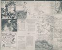
| Date: | 1926 |
|---|---|
| Description: | These maps are composites of selected exhibits and evidence submitted to the Supreme Court by the states of Wisconsin and Michigan between 1923 and 1926. T... |

| Date: | 1904 |
|---|---|
| Description: | Map showing lots, additions, and wards within the city limits, as well as some landownership. The streets are labeled, as is Lake Winnebago, rivers, railro... |

| Date: | 1770 |
|---|---|
| Description: | The south west sheet of a four sheet map of Virginia, showing the counties, mountains, rivers, court houses, a few cities, and mills. A few Plantations ar... |

| Date: | 1795 |
|---|---|
| Description: | Map of Connecticut showing counties, townships, cities, roads, islands, swamps, hills, mountains, lakes, rivers, reefs, and numerous other geographical and... |

| Date: | 1789 |
|---|---|
| Description: | Map of New York City showing ward boundaries, ferries, streets, roads, swamps, ponds, and rivers. The properties of Lispinard, Byards, Jones, Rutgers, and ... |

| Date: | 1779 |
|---|---|
| Description: | Map of North Carolina showing counties, cities, towns, chapels, courthouses, Quaker meeting houses, forts, mountains, swamps, inlets, lakes, and rivers. A ... |

| Date: | 1795 |
|---|---|
| Description: | Map of North Carolina showing counties, cities, towns, courthouses, forts, roads, mountains, swamps, inlets, waterfalls, lakes, and rivers. A dotted square... |

| Date: | 1795 |
|---|---|
| Description: | Map of South Carolina showing the precincts, cities, towns, Native American villages (marked with a triangle), courthouses, roads, mountains, swamps, islan... |

| Date: | 01 05 1955 |
|---|---|
| Description: | Elevated view of two people breaking ice with an ax and an ice breaking pole [a gaff?]; other people in the background are standing in a boat pushing poles... |
If you didn't find the material you searched for, our Library Reference Staff can help.
Call our reference desk at 608-264-6535 or email us at: