 Filter: Subject of rivers
Filter: Subject of mississippi river
Filter: Subject of rivers
Filter: Subject of mississippi river

| Date: | 1975 |
|---|---|
| Description: | Woman in a boat showing a fish she has just caught on the Mississippi River. |

| Date: | 1856 |
|---|---|
| Description: | This landscape painting by Samuel Marsden Brookes and Thomas H. Stevenson depicts a broad view of the confluence of Bad Axe and Mississippi Rivers; site of... |

| Date: | 1886 |
|---|---|
| Description: | This map shows U.S. land offices, completed railroads, railroad land grant limits, lakes, rivers, and Indian reservations. Communities, lakes, and rivers a... |

| Date: | 1874 |
|---|---|
| Description: | This map shows lakes, rivers, state, county, and town boundaries, as well as railroads completed, in progress, and contemplated. The map includes a color d... |

| Date: | 1870 |
|---|---|
| Description: | During the War of 1812, the only battle fought in Wisconsin was in Prairie du Chien, in 1814. Made fifty-six years later, this birds eye drawing depicts th... |

| Date: | 1803 |
|---|---|
| Description: | Cours du Mississippi : comprenant la Louisiane, les 2 Florides, une partie des Etats-Unis, et pays adjacents. |

| Date: | 1848 |
|---|---|
| Description: | In 1849, northern Wisconsin was composed of huge sectional regions such as Chippewa, Portage, Brown and Crawford, whereas southern Wisconsin was constitute... |

| Date: | 1907 |
|---|---|
| Description: | Aerial view of the Mississippi River with log rafts. |

| Date: | 1905 |
|---|---|
| Description: | View from across the Mississippi River of Alma, looking north. |
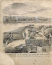
| Date: | |
|---|---|
| Description: | Drawing of a section of a completed part of Fort Cairo facing the confluen [sic] of the Mississippi and Ohio rivers. |
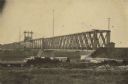
| Date: | 1866 |
|---|---|
| Description: | Clinton Bridge which crossed the Mississippi River at Clinton, Iowa. |
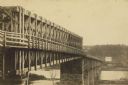
| Date: | |
|---|---|
| Description: | A carte-de-visite of an 1790 foot long bridge, 90 feet above the Mississippi River, with the main span at a length of 240 feet in length, at Saint Paul Min... |

| Date: | 1947 |
|---|---|
| Description: | The Passenger Pigeon Monument was designed and built around 1947. It was erected by the Wisconsin Society for Ornithology. |

| Date: | 1804 |
|---|---|
| Description: | A map of Lewis and Clark's Track across the western portion of North America from the Mississippi River to the Pacific Ocean by order of the Executive of t... |

| Date: | 1829 |
|---|---|
| Description: | Cincinnati, Ohio, Ebr. Martin, engraver. |

| Date: | 1835 |
|---|---|
| Description: | Constructed for the Topographical Bureau [Wash.], 1835. Scale: 16 miles to 1 inch. Map of a portion of the Indian country lying east and west of the Missis... |

| Date: | 1870 |
|---|---|
| Description: | Half stereograph of an elevated view from hill showing the confluence of the Mississippi River and the St. Croix River. A man wearing a hat is in the foreg... |

| Date: | 1882 |
|---|---|
| Description: | This basic reference map of the state shows natural features, railroads, county seats, and political boundaries against the G.L.O. township and range grid.... |

| Date: | 1910 |
|---|---|
| Description: | Wisconsin Geological and Natural History Survey, by Lawrence Martin reproduced from a model of the state prepared by W.O. Hotchkiss and F.T. Thwaites and m... |

| Date: | 1868 |
|---|---|
| Description: | Showing the counties, towns and railroads. Partly colored. Scale: 1 inch = 20 miles. |
If you didn't find the material you searched for, our Library Reference Staff can help.
Call our reference desk at 608-264-6535 or email us at: