 Filter: Subject of rivers
Filter: Subject of ponds
Filter: Subject of rivers
Filter: Subject of ponds

| Date: | 1874 |
|---|---|
| Description: | Bird's-eye map of Chippewa Falls. |

| Date: | 1892 |
|---|---|
| Description: | Bird's-eye view of the Columbian Exposition pavilions from the vantage point of Lake Michigan. Included is an inset of the Union Passenger Station (now Uni... |
| Date: | 1905 |
|---|---|
| Description: | Elevated view of a pond, a stream, and a lake, with a road dividing the pond and stream from the lake. Industrial buildings and a smokestack are in the bac... |
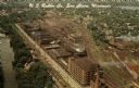
| Date: | |
|---|---|
| Description: | Aerial view of the plant, with railroad tracks along both sides of the property. A river is on the left. Several cars are parked at the plant. There is an... |
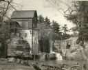
| Date: | 1948 |
|---|---|
| Description: | Abandoned mill, formerly called the Modena Roller Mills. The first mill was built in 1865 (now torn down). |

| Date: | 1900 |
|---|---|
| Description: | Elevated view of parade turning from Nebraska Street onto Main Street. Women with umbrellas line the sidewalk in the foreground of the image. The Montello ... |

| Date: | 1825 |
|---|---|
| Description: | Portion of a map showing a survey of Lake Superior including the River St. Louis. |

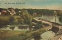
| Date: | 1905 |
|---|---|
| Description: | View of the lagoon and surrounding wooded area in Tenney Park. Caption reads: "Lagoon in Tenney Park, Madison, Wis." |

| Date: | 1907 |
|---|---|
| Description: | Bridge and Lagoon in Tenney Park. Caption reads: "Bridge and Lagoon, Tenney Park, Madison, Wisconsin." |

| Date: | |
|---|---|
| Description: | Color photograph of a man driving an International 2444 tractor with a No. 110 Balanced Head Mower. The tractor is mowing near the shoreline of a pond or ... |
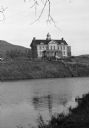
| Date: | |
|---|---|
| Description: | View from shoreline across water toward an unidentified school building with an ornate bell tower on the roof on the bank of a river or large pond. A hill ... |

| Date: | 1900 |
|---|---|
| Description: | A man leads two horses pulling a McCormick automatic self-rake reaper through a field while another man follows behind. In the background is a river or pon... |

| Date: | |
|---|---|
| Description: | Two views of the Prairie Dells dam site including the pond, the falls and the power house. |

| Date: | |
|---|---|
| Description: | Elevated view of a landscape in the Pacific islands, probably Hawaii. |

| Date: | 1866 |
|---|---|
| Description: | View of earthworks at the battlefield at Resacca. Dirt roads cross the field in the distance, leading to a farm and what appears to be a river. Plate 22... |

| Date: | 10 1884 |
|---|---|
| Description: | Sanborn insurance map of Black River Falls covering the area bordered by the Black River on the East, 3rd Street on the West, Johnson Street on the North, ... |

| Date: | 1883 |
|---|---|
| Description: | This birdseye view map reads: ""MERRILLAN JACKSON COUNTY, WISCONSIN. LOOKING FROM POSITION NORTH EAST ON THE TOWN." At the bottom are points to interest th... |

| Date: | 1900 |
|---|---|
| Description: | This map of Bangor is ink and pencil on cloth. The map shows roads, railroads, residences, mills, the original plat of Bangor, and the Wisconsin and Wheldo... |
If you didn't find the material you searched for, our Library Reference Staff can help.
Call our reference desk at 608-264-6535 or email us at:

