 Filter: Subject of slavery
Filter: Subject of land use
Filter: Subject of slavery
Filter: Subject of land use
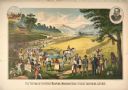
| Date: | 1883 |
|---|---|
| Description: | Advertising lithograph depicting the first public demonstration of a mechanical reaper by Cyrus Hall McCormick at Steeles Tavern, Virginia, in 1831. The sc... |
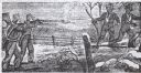
| Date: | 1849 |
|---|---|
| Description: | Drawing of two slave catchers pointing guns at two runaway slaves. |

| Date: | 1877 |
|---|---|
| Description: | Monument to John Brown and the men killed during the Battle of Osawatomie. Those slain in the battle are buried underneath the monument. Chain link fence s... |

| Date: | 1854 |
|---|---|
| Description: | Brightly-colored map exhaustively marks the townships, County Towns and villages of Wisconsin. It also shows rivers, canals, railroads, and plank roads. Ea... |

| Date: | 1855 |
|---|---|
| Description: | Drawn seven years after Wisconsin entered statehood, this map shows the counties, cities, towns, rivers and lakes in the entire state. The map includes a c... |
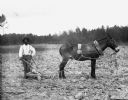
| Date: | 05 1902 |
|---|---|
| Description: | Carlos Christian cultivating a field for cotton. He is posing while holding a plow which is hitched to a mule. Pine trees are running along the perimeter o... |

| Date: | 1915 |
|---|---|
| Description: | Copy of chromolithograph of the testing of the first reaping machine at Steele's Tavern, W. Virginia." The scene includes racist depictions of enslaved Afr... |

| Date: | 1770 |
|---|---|
| Description: | The south west sheet of a four sheet map of Virginia, showing the counties, mountains, rivers, court houses, a few cities, and mills. A few Plantations ar... |

| Date: | 1755 |
|---|---|
| Description: | Map of Virginia and parts of Maryland, North Carolina, and New Jersey. It shows borders, boundary lines, some Native American land, counties, cities, towns... |
If you didn't find the material you searched for, our Library Reference Staff can help.
Call our reference desk at 608-264-6535 or email us at: