Filter: Subject of transportation
Filter: Year of 1800-1899
Filter: Year of 1830-1839
Filter: Subject of transportation
Filter: Year of 1800-1899
Filter: Year of 1830-1839
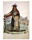
| Date: | 1835 |
|---|---|
| Description: | Waa-Na-'Taa or The Foremost in Battle, Chief of the Sioux Tribe. Hand-colored lithograph from the Aboriginal Portfolio, painted at the Treaty of Prairie du... |

| Date: | 06 1837 |
|---|---|
| Description: | Lithograph based on a painting by Mrs. E.E. Bailey showing the Peck cabin, the first house in Madison. In addition to the cabin, the lithograph includes a ... |

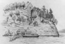
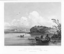
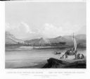
| Date: | 1835 |
|---|---|
| Description: | Little Lake Butte Des Morts just north of Lake Winnebago where Governor Lewis Cass of Michigan, and Thomas McKenney, head of the Bureau of Indian Affairs (... |

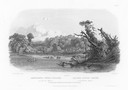
| Date: | 1834 |
|---|---|
| Description: | Peck-a-ton-oka (Pecatonica River) with Rodolf farm in the background. |
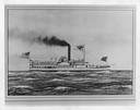
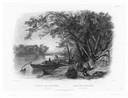
| Date: | 1832 |
|---|---|
| Description: | An early type of sidewheel passenger and freight steamboat The Milwaukie, also known as The Milwaukee. It was used on Lake Erie and upper lak... |
| Date: | 1832 |
|---|---|
| Description: | Steamboat navigating through sunken trees on the Missouri River. |
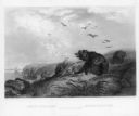
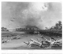
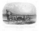
| Date: | 1832 |
|---|---|
| Description: | Travellers setting up camp along the Missouri River. |
| Date: | 1832 |
|---|---|
| Description: | Punka Indians encamped on the banks of the Missouri River and canoeing in river. |
| Date: | 1832 |
|---|---|
| Description: | Mih-Tutta-Hangkusch, a Mandan village with boats on the river in foreground. |
| Date: | 1832 |
|---|---|
| Description: | Two dog-sledges hauling supplies, with one also carrying a Mandan. |
| Date: | 1832 |
|---|---|
| Description: | Camp of the Gros Ventres along the upper Missouri River, with white travelers passing by in a boat. |

| Date: | 1832 |
|---|---|
| Description: | Hand-drawn map in two parts of the route of Governor J.D. Doty. Probably made by Doty in 1832 as a result of his travels with Alexander J. Center. |

| Date: | 1836 |
|---|---|
| Description: | The top map is the "Plat of Madison the Capitol of Wisconsin." The bottom map is the "Map of the Four Lake Country. Taken from the Township Maps in the U.S... |

| Date: | 1833 |
|---|---|
| Description: | Map of part of the military road from Fort Crawford to Fort Howard. "Recorded on pages 668.669 Book B." Surveyed by Lieut. Center. Scale: 2 miles = 1 inch. |

| Date: | 1836 |
|---|---|
| Description: | Map of the northern parts of Ohio, Indiana, and Illinois with Michigan and the part of "Ouisconsin" lying east of the Mississippi River. |

| Date: | 1831 |
|---|---|
| Description: | Map of the United States "constructed from the latest authorities," including a statistical table. |

| Date: | 07 01 1836 |
|---|---|
| Description: | Original plat map of the town of Madison on the four lakes. |
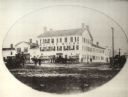
| Date: | 1839 |
|---|---|
| Description: | Exterior view of the Racine House with multiple horse-drawn wagons and figures standing in front. |
If you didn't find the material you searched for, our Library Reference Staff can help.
Call our reference desk at 608-264-6535 or email us at: