 Filter: Subject of weapons
Filter: Subject of maps
Filter: Subject of weapons
Filter: Subject of maps

| Date: | 02 1971 |
|---|---|
| Description: | Political propaganda poster featuring a red, white, and blue eagle being struck down from the sky, accompanied by the phrase: "Strike Him Down." The eagle... |

| Date: | |
|---|---|
| Description: | A tinted tintype of a Civil War soldier posing with an officer's sword in front of an elaborately painted studio backdrop depicting a tent, an American fla... |

| Date: | 1942 |
|---|---|
| Description: | Holiday card with a silhouette of a soldier with his gun, walking across a map of Germany outlined in red. The word "GERMANY" is printed in gray over it. I... |

| Date: | 1942 |
|---|---|
| Description: | Officers and non-commissioned officers squatting to consult a map on the ground near Fort Davis, Panama. The men are wearing fatigues and have sub-machine ... |

| Date: | 01 20 1945 |
|---|---|
| Description: | Label submitted to the State of Wisconsin for trademark registration. Features the shape of the state of Wisconsin outlined in blue and filled in with yell... |
| Date: | 1976 |
|---|---|
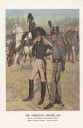
| Description: | "A general staff officer stands in the left foreground in the single-breasted blue coat with black herringbone false buttonholes on the chest and cuffs and... |

| Date: | 1952 |
|---|---|
| Description: | Front cover and menu page for a banquet given by the Instituto Mexicano del Seguro Social to the senior delegates to the fourth reunion of the Inter-Americ... |

| Date: | 1982 |
|---|---|
| Description: | This map shows the location of major settlement regions for various ethnic groups. Includes a legend in lower left hand corner. Sparse settlement is repres... |

| Date: | 1746 |
|---|---|
| Description: | A map of the western hemisphere, including parts of western Europe and Africa, showing the division of the Americas by the European powers. Weapons and fol... |

| Date: | 1755 |
|---|---|
| Description: | This map shows the eastern half of North America during the French and Indian war, including cities, borders, Native American Land, forts, and detailed geo... |
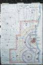
| Date: | 1960 |
|---|---|
| Description: | Map showing the probable blast radius of a 20 megaton bomb on Milwaukee. The map also shows existing hospitals in the area, including outside Milwaukee Cou... |
If you didn't find the material you searched for, our Library Reference Staff can help.
Call our reference desk at 608-264-6535 or email us at: