 Filter: Subject of wisconsin
Filter: Subject of lakes
Filter: Subject of wisconsin
Filter: Subject of lakes

| Date: | 1893 |
|---|---|
| Description: | Back of painting reads: "Madison in June 1837 after photo taken by E.E. Bailey" and "Peck's cabin by Dengel." The Eben Peck cabin was the first house built... |

| Date: | 06 1837 |
|---|---|
| Description: | Lithograph based on a painting by Mrs. E.E. Bailey showing the Peck cabin, the first house in Madison. In addition to the cabin, the lithograph includes a ... |
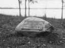
| Date: | |
|---|---|
| Description: | View of a rock with a plaque that reads: "Group of Prehistoric Indian Burial Mounds and Winnebago Village Site. Marked by the Delavan Woman's Club - May 19... |
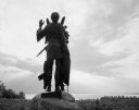
| Date: | 1963 |
|---|---|
| Description: | Statue of Winnebago Indian Chief Red Bird, with Lake Winnebago in the background. |
| Date: | 1877 |
|---|---|
| Description: | Photograph of a painting of the exterior of the Eben Peck cabin by Mrs. E.E. Bailey. The location of this original painting is unknown. |
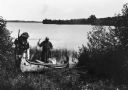
| Date: | |
|---|---|
| Description: | Two Indians are launching a new canoe, possibly on Flambeau Lake. |

| Date: | |
|---|---|
| Description: | Map reads: "Historic and Scenic Wisconsin — Land of Gathering Waters." In an inset there is a hand-painted depiction of the Wisconsin State Seal. For some ... |

| Date: | 1688 |
|---|---|
| Description: | This map includes vignettes of Amerindian life with text describing geography, culture, and exploration activity, written in French. The Great Lakes, river... |

| Date: | 1952 |
|---|---|
| Description: | The famous Dells of the Wisconsin River. A souvenir map embellished with bits of history and points of interest. |

| Date: | 1927 |
|---|---|
| Description: | Blueprint-style map of Frost Woods on the shore of Lake Monona. The map indicates the locations of Indian mounds, an Indian camp, and various plants. There... |

| Date: | 1941 |
|---|---|
| Description: | Hand-drawn, watercolor and ink, map of Lake Mendota. Locations and many small figures appear around the shore with explanations referring to Indian legends... |

| Date: | 1930 |
|---|---|
| Description: | This map shows Indian trails through Wisconsin counties. The trail are in red ink. Lake Michigan, Green Bay, Lake Superior, and the Wisconsin River are lab... |

| Date: | 1905 |
|---|---|
| Description: | A reproduction of the Wisconsin portion of Louis Hennepin's 1698 map showing the location of the Ho-Chunk Tribe, the Hurons, the Illinois as well as other ... |

| Date: | 1846 |
|---|---|
| Description: | A hand-colored map of Wisconsin shows the counties in the state south and east of the Wisconsin and Fox rivers and the locations of Indian lands to the nor... |

| Date: | 1899 |
|---|---|
| Description: | This color map, originally published in the Smithsonian Institution Bureau of American Ethnology's 18th annual report, shows the Indian land cessions in Wi... |

| Date: | 1858 |
|---|---|
| Description: | A survey map that shows the status of township surveys in Wisconsin. At that point, the majority of the state had been surveyed and platted, with the area... |

| Date: | 1939 |
|---|---|
| Description: | Label submitted to the state of Wisconsin for trademark registration. "Superfine Marathon Beer, Marathon City Brewing Company." In the foreground of the im... |

| Date: | 1880 |
|---|---|
| Description: | A hand-colored map of the Chippewa, Price, Taylor and the northern part of Clark counties, which shows the locations of farmhouses, schoolhouses, churches,... |

| Date: | 1851 |
|---|---|
| Description: | A survey map of Wisconsin and eastern Minnesota, with the township surveys for portions of the Saint Croix region in progress. The maps also show the Meno... |

| Date: | 1916 |
|---|---|
| Description: | In 1916, it was estimated that 15,000 Indian mounds had formerly existed in Wisconsin. In the early 20th century, the Wisconsin Archaeological Society surv... |
If you didn't find the material you searched for, our Library Reference Staff can help.
Call our reference desk at 608-264-6535 or email us at: