 Filter: Subject of wisconsin river (wis.)
Filter: Subject of lakes
Filter: Subject of wisconsin river (wis.)
Filter: Subject of lakes

| Date: | 1936 |
|---|---|
| Description: | This map is red and black ink on tracing cloth and is oriented with north to the upper left. This hand-drawn map shows a central portion of the military ro... |

| Date: | 1861 |
|---|---|
| Description: | Drawn the first year of the Civil War, this colored 1861 map of Dane County shows its towns, cities and lakes. It includes insets of the wards of Madison a... |

| Date: | 1868 |
|---|---|
| Description: | Bird's-eye map of Portage, with insets of the Court House and the Public School. |
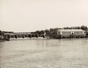
| Date: | 1959 |
|---|---|
| Description: | The Kilbourn Hydroelectric Plant of the Wisconsin Power and Light Company. |
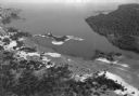
| Date: | 1930 |
|---|---|
| Description: | Aerial view of Lake Delton, the Wisconsin River, and the surrounding countryside. |
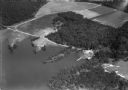
| Date: | 1930 |
|---|---|
| Description: | Aerial view of Lake Delton and shoreline including resort areas. |

| Date: | 1868 |
|---|---|
| Description: | Showing the counties, towns and railroads. Partly colored. Scale: 1 inch = 20 miles. |
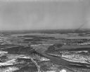
| Date: | 04 16 1949 |
|---|---|
| Description: | Aerial view of Petenwell Dam and dike on Wisconsin River twenty miles north of Necedah, Wisconsin showing the early formation of Lake Petenwell. |

| Date: | 1896 |
|---|---|
| Description: | Section 5 of 12, this bicycle road map features Wisconsin bicycle routes in the counties of La Crosse, Monroe, Vernon, Crawford, Richland, Sauk, Juneau, an... |

| Date: | 1913 |
|---|---|
| Description: | A wall atlas of Sauk County, Wisconsin, displaying its 22 towns. On the left side are advertisements for local businesses. |

| Date: | 1952 |
|---|---|
| Description: | The famous Dells of the Wisconsin River. A souvenir map embellished with bits of history and points of interest. |

| Date: | 1935 |
|---|---|
| Description: | This map shows Wisconsin’s pinery region. Lake Superior, Lake Michigan, Lake Winnebago, Green Bay, the Wisconsin River, and the Mississippi River are label... |

| Date: | 1991 |
|---|---|
| Description: | This canoe guide depicts the Wisconsin River from just north of Prairie du Sac to near Spring Green. Landmarks and points of interest are identified and de... |

| Date: | 1835 |
|---|---|
| Description: | Ink on tracing paper map of Green Bay, Wisconsin and nearby areas, Lake Winnebago, Fox and Wolf Rivers, and the junctions of the Mississippi and Wisconsin ... |

| Date: | 1899 |
|---|---|
| Description: | This color map, originally published in the Smithsonian Institution Bureau of American Ethnology's 18th annual report, shows the Indian land cessions in Wi... |

| Date: | 1896 |
|---|---|
| Description: | A map showing the Wisconsin Central Railroad lines in Wisconsin, northern Illinois, eastern Minnesota, and Michigan’s Upper Peninsula. The area of the map ... |

| Date: | 1900 |
|---|---|
| Description: | A map of Wisconsin, eastern Minnesota and Iowa, northern Iowa, and Michigan’s Upper Peninsula, showing railway lines, with those marked with heavy red line... |

| Date: | 1900 |
|---|---|
| Description: | This map, which shows the state of Wisconsin in 1895, was published as Rand, McNally & Co.'s New business atlas map of Wisconsin. Railroads, counties, citi... |

| Date: | 1900 |
|---|---|
| Description: | A map of Wisconsin, eastern Minnesota and Iowa, and Michigan’s Upper Peninsula, showing the rail lines of the Wisconsin Central Railroad are shown in red, ... |

| Date: | 1847 |
|---|---|
| Description: | A geological, hand-colored map of Wisconsin north and west of the Wisconsin River, as well as portions of eastern Minnesota and Iowa from the Mississippi t... |
If you didn't find the material you searched for, our Library Reference Staff can help.
Call our reference desk at 608-264-6535 or email us at: