 Filter: Subject of writing
Filter: Subject of indians of north america
Filter: Subject of writing
Filter: Subject of indians of north america

| Date: | 1876 |
|---|---|
| Description: | A sketch map of the procession of Indian mounds on the two ridged field sites in Grant County. |

| Date: | |
|---|---|
| Description: | Studio portrait in front of a painted backdrop of a Ho-Chunk man posed sitting on a prop fence on the left writing a letter on a small table with his right... |
| Date: | |
|---|---|
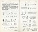
| Description: | A chart of characters used in Ojibway/Ojibwa picture writing. |

| Date: | 1905 |
|---|---|
| Description: | This pictorial representation of part of Lake Winnebago and the Fox River in 1703, showing interactions between white beaver hunters and the Iroquois is ta... |

| Date: | 1780 |
|---|---|
| Description: | Map of North and South America, showing the boundaries of colonial territories, cities, settlements, rivers, lakes, and Native American land. Particular em... |

| Date: | 1747 |
|---|---|
| Description: | Map of America showing rivers, lakes, mountains, and regions, but primarily focusing on the French and Native American settlements along the Mississippi th... |

| Date: | 1758 |
|---|---|
| Description: | Map showing lakes, rivers, cities, Native American land, and the boundaries of French and English claims in America and Canada north of New York. A title c... |

| Date: | 1676 |
|---|---|
| Description: | Map of Virginia and Maryland, based on John Smith's 1612 map and Augustine Herman's 1673 seminal map. It shows borders, counties, Native American land, tri... |
If you didn't find the material you searched for, our Library Reference Staff can help.
Call our reference desk at 608-264-6535 or email us at: