 Filter: Year of 1600-1699

| Date: | 1675 |
|---|---|
| Description: | Map of the southeast coast of North America from Jamestown to modern Georgia. It shows European settlements, Native American land and villages, coastal fea... |

| Date: | 1667 |
|---|---|
| Description: | Map of Virginia depicting the discoveries detailed by John Smith in his exploration of the region. It shows Jamestown, Native American tribes and villages,... |

| Date: | 1671 |
|---|---|
| Description: | Map of Virginia depicting the discoveries detailed by John Smith in his exploration of the region. It shows Jamestown, Native American tribes and villages,... |

| Date: | 1676 |
|---|---|
| Description: | Map of Virginia and Maryland, based on John Smith's 1612 map and Augustine Herman's 1673 seminal map. It shows borders, counties, Native American land, tri... |
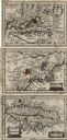
| Date: | 1675 |
|---|---|
| Description: | Three maps found within John Speed's atlas A Prospect of the Most Famous Parts of the World along with the corresponding text. The first map shows V... |

| Date: | 1612 |
|---|---|
| Description: | Map of New France, the area that is now eastern Canada and north eastern United States, showing lakes, rivers, and landforms. The locations of several Nati... |

| Date: | 1609 |
|---|---|
| Description: | Illustration of an elevated view of a battle between Iroquois tribe and French on the banks of river. The Iroquois are unclothed and armed with bows and ar... |

| Date: | 1615 |
|---|---|
| Description: | Illustration of the Huron Indians and French explorers attacking an Iroquois fort near present day Fenner, New York. A wooden platform was constructed to f... |

| Date: | 1608 |
|---|---|
| Description: | Illustraiton, with alphabetical key in French, of the Habitation of Quebec, a conglomeration of connected buildings on the banks of the St. Lawrence River ... |
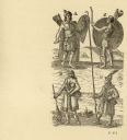
| Date: | 1615 |
|---|---|
| Description: | Drawings of four Native Americans. A and C are dressed for combat. B appears to be a woman carrying and nursing an infant, and D is wearing winter garb, in... |
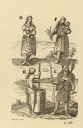
| Date: | 1616 |
|---|---|
| Description: | Illustration of four Algonquian Indians. E depicts a man dressed for combat in wood armor. F shows a woman in her regular dress carrying a child and an ear... |
| Community: | Milwaukee |
|---|---|
| County: | Milwaukee |
| Historic Name: | Haida Indian Pole |
| Reference Number: | 111503 |

| Community: | Portage |
|---|---|
| County: | Columbia |
| Historic Name: | Fox-Wisconsin Portage Site |
| Reference Number: | 3695 |
If you didn't find the material you searched for, our Library Reference Staff can help.
Call our reference desk at 608-264-6535 or email us at:
