 Filter: Year of 1700-1799
Filter: Year of 1790-1799
Filter: Year of 1700-1799
Filter: Year of 1790-1799
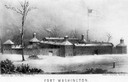
| Date: | 1790 |
|---|---|
| Description: | Fort Washington, built in 1789, where Cincinnati now stands. |

| Date: | 1790 |
|---|---|
| Description: | Map of the region surrounding Dayton, Ohio showing rivers and other settlements, with a table of distances from Cincinnati to Dayton and to points outside ... |
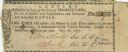
| Date: | 1795 |
|---|---|
| Description: | State of Pennsylvania Lottery ticket authorised by law to benefit the Schuylkill and Susquehanna, and Delaware and Schuylkill Canals. |

| Date: | 1798 |
|---|---|
| Description: | Uncolored. No scale. One of the earliest maps to show the proposed division of the northwest territory into states. |

| Date: | 1792 |
|---|---|
| Description: | Map of Washington D.C. Labeled on the map are all the main streets, the site of the Capitol and the President's House. The map also shows the relationship ... |

| Date: | 1798 |
|---|---|
| Description: | Engraved and hand-colored map of Egypt. Map title appears on bottom left as a carving in stone next ... |

| Date: | 02 01 1793 |
|---|---|
| Description: | Text in the upper right corner reads, "A Map of The Western Part of the Territories belonging to the United States of America. Drawn from the best authorit... |
| Date: | 1792 |
|---|---|
| Description: | This map depicts the fixed boundaries by a peace treaty between the United States and the Spanish Dominions. |

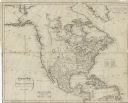
| Date: | 1790 |
|---|---|
| Description: | An updated and corrected version of Robert de Vaugondy's 1750 map "Amérique Septentrionale: Dressée sur les Relations les Plus Modernes des Voyageurs et Na... |

| Date: | 1791 |
|---|---|
| Description: | An English and updated version of d'Anville's 1746 map "Amérique Septentrionale Publiée sous les Auspices de Monseigneur le Duc d'Orleans Prémier Prince du... |

| Date: | 1790 |
|---|---|
| Description: | This map of the north eastern states shows roads, rivers, lakes, waterfalls, mountains, cities, forts, mills, the Oneida Reservation, and "New York Donatio... |

| Date: | 1790 |
|---|---|
| Description: | An ink and hand-colored map, showing the land and landowners of the Susquehanna company purchase in Pennsylvania. Rivers are shown and occasionally labeled... |

| Date: | 1790 |
|---|---|
| Description: | Map of North America showing cities, states, Native American land, regions, lakes, and rivers. A few notes appear throughout the map, particularly west of ... |
| Date: | 1794 |
|---|---|
| Description: | Map of North America showing cities, trading houses, Native American land, settlements, missions, mountains, lakes, and rivers, all in great detail. The ma... |

| Date: | 1796 |
|---|---|
| Description: | An interesting depiction of North America from the North Pole to the beginning of South America. The continent appears elongated. The map features numerous... |

| Date: | 1799 |
|---|---|
| Description: | Map of North America from the Great Lakes region to Baffins Bay. It shows settlements, Native American land, cities, trading houses and forts, mountains, a... |

| Date: | 1794 |
|---|---|
| Description: | Map of the United States east of the Mississippi River. It shows borders, treaty lines, forts, cities, towns, Native American land, mountains, swamps, lake... |
| Date: | 1799 |
|---|---|
| Description: | Map of the United States east of the Mississippi River. It shows borders, treaty lines, forts, cities, towns, Native American land, mountains, swamps, lake... |

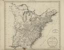
| Date: | 1792 |
|---|---|
| Description: | Map of the United States east of the Mississippi River and north of the Ohio River. It shows the borders between the north eastern states, Canada and the U... |

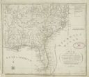
| Date: | 1794 |
|---|---|
| Description: | Extremely detailed map of the south-eastern states, south from Virginia and east of the Mississippi River. It shows roads and paths, cities, towns, forts, ... |
If you didn't find the material you searched for, our Library Reference Staff can help.
Call our reference desk at 608-264-6535 or email us at: