 Filter: Year of 1800-1899
Filter: Subject of cities and towns
Filter: Year of 1840-1849
Filter: Year of 1844
Filter: Year of 1800-1899
Filter: Subject of cities and towns
Filter: Year of 1840-1849
Filter: Year of 1844
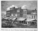
| Date: | 1844 |
|---|---|
| Description: | Illustration of the west side of East Water Street. |
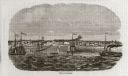
| Date: | 10 1844 |
|---|---|
| Description: | A variant of a wood engraving dated October, 1844. Incorporated as the villige of Southport in 1841 (so-named because it was the southern-most natural harb... |
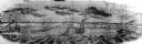
| Date: | 10 1844 |
|---|---|
| Description: | View from a pile-driver on the north pier of the community then known as Southport. The pier visible at left center, constructed between 1840-1842, was th... |

| Date: | 1844 |
|---|---|
| Description: | Map of Wisconsin including Lakes Michigan and Superior. Inset includes "N.W. Part of Wiskonsan." |

| Date: | 1844 |
|---|---|
| Description: | Wisconsin was considered part of Michigan Territory until 1836, a year before Michigan entered statehood. Drawn four years before Wisconsin entered stateho... |

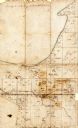
| Date: | 1844 |
|---|---|
| Description: | An ink on paper, hand-drawn map of Milwaukee County that shows the sectioning of townships, the boundary of the canal grant, roads, streams, lakes, includi... |

| Ever wonder why beer is so popular in Wisconsin? Wisconsin history is full of breweries and beer. |
| Learn more about the 1904 fire that destroyed the third Wisconsin State Capitol. |
| Date: | 1844 |
|---|---|
| Description: | This map of Township number 24 North, Range 21 East is pen and ink on paper. The map also shows part of Township Number 23 North, Range Number 21 East. The... |
If you didn't find the material you searched for, our Library Reference Staff can help.
Call our reference desk at 608-264-6535 or email us at: