 Filter: Year of 1800-1899
Filter: Subject of cities and towns
Filter: Year of 1840-1849
Filter: Year of 1845
Filter: Year of 1800-1899
Filter: Subject of cities and towns
Filter: Year of 1840-1849
Filter: Year of 1845

| Date: | 1845 |
|---|---|
| Description: | Wisconsin was considered part of Michigan Territory until 1836, a year before Michigan entered statehood. Drawn three years before Wisconsin entered stateh... |
| Date: | 1845 |
|---|---|
| Description: | This manuscript map, drawn about 1845, shows the township and range grid, villages, post offices, and roads in Kenosha, Racine, and Walworth counties and i... |

| Ever wonder why beer is so popular in Wisconsin? Wisconsin history is full of breweries and beer. |
| Learn more about the 1904 fire that destroyed the third Wisconsin State Capitol. |

| Date: | 1845 |
|---|---|
| Description: | This map shows lot and block numbers, local streets, railroads, some landowners’ names, Milwaukee River, Menomonee River, and part of Lake Michigan. The ma... |

| Date: | 06 1845 |
|---|---|
| Description: | This map is pen-and-ink on paper and shows the numbers, dimensions, and acreages of lots, as well as survey monuments and streets. Also included is a certi... |
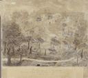
| Date: | 1845 |
|---|---|
| Description: | Drawing of Shullsburg. Text at bottom reads: "Smelting lead ore in log furnaces. Scene in Gratiots Grove at Shullsburg, Wis. in 1845-6. Drawn from life. By... |
If you didn't find the material you searched for, our Library Reference Staff can help.
Call our reference desk at 608-264-6535 or email us at: