 Filter: Year of 1800-1899
Filter: Subject of cities and towns
Filter: Year of 1850-1859
Filter: Year of 1800-1899
Filter: Subject of cities and towns
Filter: Year of 1850-1859

| Date: | 1850 |
|---|---|
| Description: | A hand-colored map showing portions of present-day Iron and Vilas counties north of the Manitowish River as part of the Upper Peninsula of Michigan. The Wi... |

| Date: | 1855 |
|---|---|
| Description: | Drawn around 1855, this map shows the placement of railroad tracks in southern Wisconsin and northern Illinois connecting Milwaukee, Prairie du Chien, Gale... |

| Date: | 1852 |
|---|---|
| Description: | A hand-colored map showing portions of present-day Iron and Vilas counties north of the Manitowish River as part of the Upper Peninsula of Michigan. The Wi... |

| Date: | 1851 |
|---|---|
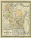
| Description: | Map exhaustively marks the townships, County Towns and villages of Wisconsin. It also shows rivers, canals, railroads, and plank roads. Each county's popul... |

| Date: | 1852 |
|---|---|
| Description: | Map shows Wisconsin counties by color and includes rivers, lakes and some cities. This information is also given for eastern Minnesota and northern Illinoi... |

| Date: | 1853 |
|---|---|
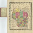
| Description: | Wisconsin counties by color and shows railroads, common roads, canals, the state capital, county towns, townships, villages, and post offices, |

| Date: | 1854 |
|---|---|
| Description: | Map of the whole state Wisconsin includes an inset of the vicinity of Milwaukee, which shows the boundaries for Lisbon, Menomonee, Pewaukee, Brookfield, Wa... |
| Date: | 1854 |
|---|---|
| Description: | This map shows portions of present-day Iron and Vilas counties north of the Manitowish River as part of the Upper Peninsula of Michigan. The Wisconsin coun... |

| Date: | 1855 |
|---|---|
| Description: | Map of Wisconsin, showing railway routes throughout the state as well as the names of the counties, townships, and cities in the state. The inset of the ma... |

| Date: | 1855 |
|---|---|
| Description: | Drawn three years before Minnesota entered statehood, this map shows Minnesota Territory and the western part of Wisconsin. The map shows county lines, riv... |

| Date: | 10 21 1855 |
|---|---|
| Description: | Map of the Wisconsin and the Minnesota Territory showing the status of township surveys in Wisconsin and southeastern Minnesota. The Wisconsin reservation... |

| Date: | 1856 |
|---|---|
| Description: | A hand-colored map of Wisconsin, showing the county boundaries, towns, cities, railroads, roads, lakes, rivers, bays, and the Lake Superior’s islands. In ... |

| Date: | 1856 |
|---|---|
| Description: | This map shows the entire state of Wisconsin with counties, cities and rivers. It includes an inset of the layout of the streets of Milwaukee and a chart w... |

| Date: | 1857 |
|---|---|
| Description: | This detailed map was drawn nearly a decade after Wisconsin entered statehood. It depicts the entire state, northern Illinois and part of the upper peninsu... |
| Date: | 1856 |
|---|---|
| Description: | This map shows the state of Wisconsin in 1856. Counties in existence at the time and the division of townships, railroads, both existing and proposed, and ... |

| Date: | 1857 |
|---|---|
| Description: | A map of the state of Wisconsin and the southeastern portion of the Territory of Minnesota, showing the Wisconsin reservations of the Oneida, Menominee, St... |
| Date: | 1857 |
|---|---|
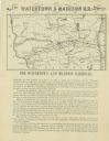
| Description: | Map shows the railroads of southern Wisconsin, highlighting the Watertown and Madison Railroad. The Watertown and Madison Railroad between those two cities... |

| Date: | 1854 |
|---|---|
| Description: | This map is ink and watercolor on tracing cloth and shows lot and block numbers, streets, a park, and depots. Some lots are colored red or blue and some in... |
| Date: | 1856 |
|---|---|
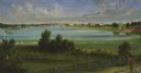
| Description: | "Three views in a short space show the peaceful appearance of what is now a busy paper mills center . . . [One of them] is Little Chute, one of the pleasan... |
| Date: | 1856 |
|---|---|
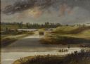
| Description: | " . . . The first in their series was not an 'improvement' but a view of the Green Bay settlement, looking downstream. From a simulated rustic fence corner... |
If you didn't find the material you searched for, our Library Reference Staff can help.
Call our reference desk at 608-264-6535 or email us at: