Filter: Year of 1800-1899
Filter: Subject of cities and towns
Filter: Year of 1830-1839
Filter: Year of 1800-1899
Filter: Subject of cities and towns
Filter: Year of 1830-1839
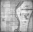
| Date: | 1836 |
|---|---|
| Description: | Map of Milwaukee including the Milwaukee River and Lake Michigan shore. |

| Date: | 1836 |
|---|---|
| Description: | Map of all Dane County and eastern towns. |

| Date: | 1839 |
|---|---|
| Description: | This map shows the hydrology of Madison and its vicinity at the height of interest in a proposed Milwaukee and Rock River Canal. It was made by Thomas Jeff... |

| Date: | 1832 |
|---|---|
| Description: | Hand-drawn map in two parts of the route of Governor J.D. Doty. Probably made by Doty in 1832 as a result of his travels with Alexander J. Center. |

| Date: | 1836 |
|---|---|
| Description: | The top map is the "Plat of Madison the Capitol of Wisconsin." The bottom map is the "Map of the Four Lake Country. Taken from the Township Maps in the U.S... |

| Date: | 1836 |
|---|---|
| Description: | Map of the northern parts of Ohio, Indiana, and Illinois with Michigan and the part of "Ouisconsin" lying east of the Mississippi River. |

| Date: | 1831 |
|---|---|
| Description: | Map of the United States "constructed from the latest authorities," including a statistical table. |

| Date: | 03 30 1835 |
|---|---|
| Description: | Map of township # 7N, range no. 10 east, 4th meridian, including Third Lake. |
| Date: | 1838 |
|---|---|
| Description: | Pencil sketch of a building owned by the Rodolf family along a commercial street. |
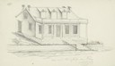
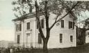
| Date: | 1838 |
|---|---|
| Description: | Pencil sketch of a stone house with a porch the full length of the dwelling, supported by 6 columns. |
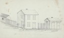
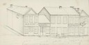
| Date: | 1838 |
|---|---|
| Description: | Pencil sketch of buildings, including the Post Office. |

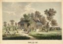
| Date: | 1837 |
|---|---|
| Description: | Fond du Lac Company House, built in 1836 and operated as an inn by Colwert Pier and his wife. Groups of Indians are in the yard outside the inn, and severa... |
| Date: | 1837 |
|---|---|
| Description: | Fond du Lac Company House. Groups of Indians are in the yard outside the inn, and several Indian dwellings are erected next to it. A man on horseback with ... |
| Date: | 1832 |
|---|---|
| Description: | People work in the garden at the Protestant Episcopal Mission Buildings. |

| Date: | 1830 |
|---|---|
| Description: | Multicolor map illustrates the development of states and territories in the Old Northwest. Wisconsin was on the frontier of settlement when this map was pu... |

| Date: | 1836 |
|---|---|
| Description: | The map of Wisconsin City on the Wisconsin River. |
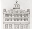
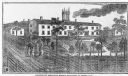
| Date: | 1838 |
|---|---|
| Description: | The Odd Fellows Hall, built in 1837-1838, was the first to be built west of the Allegheny Mountains. The cornerstones were laid by Thomas Widley. |
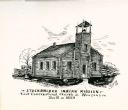
| Date: | 1835 |
|---|---|
| Description: | Drawing of the Stockbridge Indian Mission, built in about 1834. |
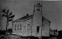
| Date: | 1835 |
|---|---|
| Description: | Drawing of the Stockbridge Indian mission. |
If you didn't find the material you searched for, our Library Reference Staff can help.
Call our reference desk at 608-264-6535 or email us at: