 Search: Grant
Search: County
Filter: Categories of Wisconsin Historical Images
Filter: Year of 1800-1899
Search: Grant
Search: County
Filter: Categories of Wisconsin Historical Images
Filter: Year of 1800-1899
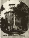
| Date: | 1867 |
|---|---|
| Description: | The Grant County Soldier's Monument was erected in 1866 and dedicated in July of 1867. |
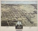
| Date: | 1875 |
|---|---|
| Description: | Bird's-eye map of Lancaster, with inset of Monument for the Soldiers of Grant County. |
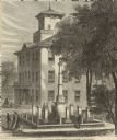
| Date: | 1868 |
|---|---|
| Description: | Elevated view of the Grant County Soldier's Monument. A group of people are standing around the monument. A large building is in the background. Caption at... |
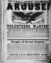
| Date: | 07 24 1862 |
|---|---|
| Description: | Poster calling for the recruitment of volunteers from Grant County for the Union Army during the Civil War. |
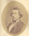
| Date: | 1856 |
|---|---|
| Description: | Quarter-length oval portrait of Robert Aiken. He was born in Alleghany County, Pennsylvania, on December 25, 1816. Aiken came to Grant County, Wisconsin in... |

| Date: | 1889 |
|---|---|
| Description: | Eight diagrams that describe the topography and vegetation of school sections in the towns of Clear Creek and Ludington in Eau Claire County; Sigel in Chip... |

| Date: | 1876 |
|---|---|
| Description: | A sketch map of the procession of Indian mounds on the two ridged field sites in Grant County. |

| Date: | 1868 |
|---|---|
| Description: | A detailed, cloth mounted map of Grant County that shows the townships, towns, roads, completed and under construction railroads, cemeteries, mills, lead m... |

| Date: | 1875 |
|---|---|
| Description: | Bird's-eye map of Platteville. |

| Date: | 1890 |
|---|---|
| Description: | This 1890s map shows the Wisconsin Central Railroad land grant lands owned and for sale by the Soo Line in Ashland County, Wisconsin, as well as in the eas... |

| Date: | 1842 |
|---|---|
| Description: | Relief shown by hachures. Shows furnaces, saw mills, houses, roads, grist mills, entries, reservations, and diggings. "Compiled by order of the Board of C... |

| Date: | 1896 |
|---|---|
| Description: | This map shows the railroad routes of the Wisconsin Central Railroad and its land grant. These are visibly marked in the color red. County boundaries are a... |

| Date: | 1844 |
|---|---|
| Description: | An ink on paper, hand-drawn map of Milwaukee County that shows the sectioning of townships, the boundary of the canal grant, roads, streams, lakes, includi... |

| Date: | 1890 |
|---|---|
| Description: | This map shows the Wisconsin Central Railroad land grant lands owned and for sale by the Soo Line in Ashland County, Wisconsin, as well as in portions of B... |

| Date: | 1869 |
|---|---|
| Description: | Birds-eye drawing of Boscobel, Grant County, depicts street names and street layouts, houses, rivers and trees. A reference key at the bottom of the map sh... |

| Date: | 1866 |
|---|---|
| Description: | This map shows the location of county boundaries, cities, rivers, lakes, grant railroads, wagon roads, land office locations, iron, copper and lead deposit... |

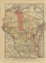
| Date: | 1885 |
|---|---|
| Description: | Caption reads: "First Soldier's Monuments Erected in the US — Lancaster Wis". There is a cannon and cannon balls on the lawn to the left of the monuments. |

| Date: | 1857 |
|---|---|
| Description: | Relief shown by hachures. "Lith. of Ed. Mendel, Chicago." Shows townships and sections, rivers, roads, railroads, houses, flour mills, saw mills, furnaces... |
| Date: | 1889 |
|---|---|
| Description: | A map that shows the railroad's lines in Wisconsin, northern Illinois, and the Upper Peninsula of Michigan. Those that are marked with a red line are those... |

| Date: | 1850 |
|---|---|
| Description: | This map of Cassville shows plat of the town, roads, landings and public wharfs and the Mississippi River. |
If you didn't find the material you searched for, our Library Reference Staff can help.
Call our reference desk at 608-264-6535 or email us at: