 Search: Madison
Filter: Categories of Wisconsin Historical Images
Filter: Year of 1900-1999
Filter: Subject of human settlements
Filter: Year of 1960-1969
Filter: Type of Map or Atlas
Search: Madison
Filter: Categories of Wisconsin Historical Images
Filter: Year of 1900-1999
Filter: Subject of human settlements
Filter: Year of 1960-1969
Filter: Type of Map or Atlas

| Date: | 1967 |
|---|---|
| Description: | Shows projects and proposed projects, some zoning districts, public housing sites (Project Wis.-3-183-4), streets, and proposed streets. Upper left hand co... |

| Date: | 1961 |
|---|---|
| Description: | Shows wards and voting precincts. Published in The Capital times: January 28, 1961. |

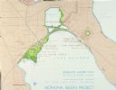
| Date: | 1968 |
|---|---|
| Description: | This blue line print map shows proposed changes reserving railroad right-of-ways for future highways, land plots, as well as Lake Monona and Lake Mendota. |

| Date: | 1966 |
|---|---|
| Description: | This map shows streets, highways, railroads, parks, colleges, cemeteries, county clubs, University of Wisconsin, Truax Field, Middleton, Shorewood Hills, M... |

| Date: | 1964 |
|---|---|
| Description: | Indexed map. Street names are to the left, map is to the right. Lakes, streets, highways, and points of interest are labelled. |

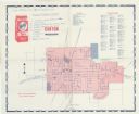
| Date: | 1960 |
|---|---|
| Description: | This map shows block numbers, tract numbers, tract boundaries, city limits, local streets, railroads, Lake Mendota, and Lake Monona. |

| Date: | 1961 |
|---|---|
| Description: | This street map includes an ancillary map of Dane County highways and a business directory. Lake Mendota, Lake Monona, Monona Bay, Yahara River, and Lake W... |
| Date: | 1967 |
|---|---|
| Description: | Schematic Master Plan for the City of Madison, Wisconsin. William Wesley Peters, Architect • The Frank Lloyd Wright Foundation. |

| Date: | 1968 |
|---|---|
| Description: | Three maps that show local streets, roads, railroads, parks, country clubs, the University of Wisconsin, Shorewood Hills, Maple Bluff, Monona, Truax Field,... |

| Date: | 1968 |
|---|---|
| Description: | Shows potential fishing areas by species and season, as well as sand and rock bars, weed beds, public facilities, points of interest, and selected business... |

| Date: | 1969 |
|---|---|
| Description: | This map is pen and ink on paper and shows the location of churches, local streets, railroads, parks, Middleton, Shorewood Hills, Monona, Maple Bluff, McFa... |
| Date: | 1963 |
|---|---|
| Description: | A map with handwritten notes and locations for Freedom Fighters participating in the Canton Boycott, for orientation during picketing. It is not a map show... |

| Date: | 1960 |
|---|---|
| Description: | This dot density map shows the number of shipments in 1952 throughout Wisconsin and to other United States destinations from Neillsville. Mellen, Cable, Bl... |

| Date: | 1960 |
|---|---|
| Description: | This colored road map shows roads in Wisconsin as well as portions of nearby states. Information on the quality and type of any road shown can be found in ... |

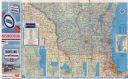
| Date: | 1965 |
|---|---|
| Description: | This colored road map shows automobile roads in Wisconsin as well as portions of nearby states. Information on the quality and type of any road shown (inte... |

| Date: | 1963 |
|---|---|
| Description: | This colored road map shows automobile roads in Wisconsin as well as portions of nearby states. The map is organized such that a single map of Wisconsin is... |
| Date: | 1963 |
|---|---|
| Description: | This colored road map shows automobile roads in Wisconsin as well as portions of nearby states. The map is organized such that a single map of Wisconsin is... |

| Date: | 1966 |
|---|---|
| Description: | This colored road map shows automobile roads in Wisconsin as well as portions of nearby states. Information on the quality and type of any road shown (inte... |
If you didn't find the material you searched for, our Library Reference Staff can help.
Call our reference desk at 608-264-6535 or email us at: