 Search: Madison
Filter: Categories of Wisconsin Historical Images
Filter: Year of 1900-1999
Filter: Year of 1950-1959
Filter: Creator Name of Newhouse, John
Filter: Year of 1954
Search: Madison
Filter: Categories of Wisconsin Historical Images
Filter: Year of 1900-1999
Filter: Year of 1950-1959
Filter: Creator Name of Newhouse, John
Filter: Year of 1954
| Date: | 1954 |
|---|---|
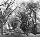
| Description: | State Street from the University of Wisconsin-Madison campus. |

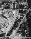
| Date: | 1954 |
|---|---|
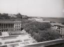
| Description: | An aerial view of the State Office Building, 1 West Wilson Street. Also shows Olin Terrace, Madison Club and the United States Post Office. |

| Date: | 1954 |
|---|---|
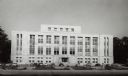
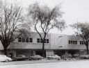
| Description: | University of Wisconsin-Madison Bacteriology Building, in process of construction on campus. There are cars in a parking lot in the foreground. |
| Date: | 1954 |
|---|---|
| Description: | Library from across lower campus mall on the University of Wisconsin-Madison campus. A parking lot with cars parked near entrance on west side. |
| Date: | 1954 |
|---|---|
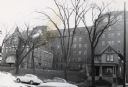
| Description: | Methodist Hospital, from West Washington Avenue. |
| Date: | 1954 |
|---|---|
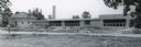
| Description: | Panoramic view of the Mendota grade school during construction. |
| Date: | 1954 |
|---|---|
| Description: | An air view of Madison including the Veterans Hospital, Forest Products Laboratory and University Avenue from Farley (lower edge), to Allen Streets. |

| Date: | 06 07 1954 |
|---|---|
| Description: | Aerial view of the Midvale neighborhood under construction showing the intersection of Midvale and Tokay Boulevards near the southwestern city limits of Ma... |
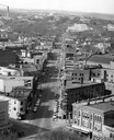
| Date: | 1954 |
|---|---|
| Description: | Elevated view of State Street looking toward Bascom Hall and the University of Wisconsin-Madison campus from the Wisconsin State Capitol dome. |
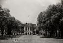
| Date: | 1954 |
|---|---|
| Description: | View of Bascom Hall from Bascom Hill (formerly Main Hall) on the University of Wisconsin-Madison campus. A few people are sitting on the lawn in front of ... |
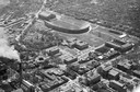
| Date: | 1954 |
|---|---|
| Description: | Aerial view of Camp Randall Stadium with the University of Wisconsin heating plant in foreground. |
| Date: | 1954 |
|---|---|
| Description: | F.W. Woolworth store on East Main Street at Monona Avenue (now Martin Luther King, Jr., Boulevard), showing the old Vilas block (aka Pioneer Building). |

| Date: | 06 07 1954 |
|---|---|
| Description: | Aerial view looking north from near the city's southwestern limits in 1954. Shows text indicating Midvale Boulevard, Odana Road, Tokay Boulevard, Mineral P... |
| Date: | 1954 |
|---|---|
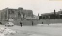
| Description: | The intersection of Mifflin Street and Wisconsin Avenue after the old City Hall (1858-1954) and Fuller Opera House had been torn down. |
| Date: | 1954 |
|---|---|
| Description: | View of the Sears-Roebuck store on East Washington Avenue. The portion of East Washington in front of the store is full of parked automobiles. |

| Date: | 1954 |
|---|---|
| Description: | Aerial view of the west side of Madison showing newly constructed homes and homes under construction featured in the Parade of Homes. The main road through... |
| Date: | 1954 |
|---|---|
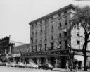
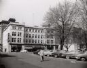
| Description: | View of the corner of Carroll and West Main Streets downtown. The Park Hotel occupies the large building. The Prescription Pharmacy, the Park Hotel Barber ... |
| Date: | 1954 |
|---|---|
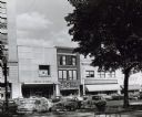
| Description: | Pinckney Street, near the corner of East Washington Avenue. To the left is a bank building, in the center a shoe store, and on the right a theatre. |
| Date: | 1954 |
|---|---|
| Description: | View from roof top of lower campus at the University of Wisconsin-Madison. Wisconsin Historical Society is in left foreground and Science Hall is visible b... |

| Date: | 1954 |
|---|---|
| Description: | View from intersection towards the Wisconsin Building, which was built in 1901. Located at the intersection of State and Carroll Streets, at 102 State Stre... |
If you didn't find the material you searched for, our Library Reference Staff can help.
Call our reference desk at 608-264-6535 or email us at: