 Search: Madison
Filter: Subject of canals
Search: Madison
Filter: Subject of canals

| Date: | 1942 |
|---|---|
| Description: | This map shows the Wisconsin and Fox River routes in green, and the Milwaukee and Rock River Canal routes in red. Prairie du Chien, Fort Winnebago, Grand C... |
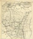
| Date: | 1878 |
|---|---|
| Description: | This map shows the advantages of the Sturgeon Bay and Lake Michigan Ship Canal, railroads, steamship lines across Lake Michigan, and Wisconsin township gri... |
If you didn't find the material you searched for, our Library Reference Staff can help.
Call our reference desk at 608-264-6535 or email us at:
