Search: State
Filter: County of Sauk
Search: State
Filter: County of Sauk
| Community: | Baraboo |
|---|---|
| County: | Sauk |
| Historic Name: | Devil's Lake State Park |
| Reference Number: | 14001192 |
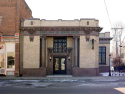
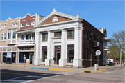
| Community: | Spring Green |
|---|---|
| County: | Sauk |
| Historic Name: | State Bank of Spring Green |
| Reference Number: | 10000463 |
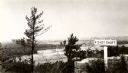
| Date: | 1945 |
|---|---|
| Description: | View from the bluff at Tower Hill State Park of the Wisconsin River. A sign on the right reads: "Tower Hill State Park Shot Shaft". |

| Date: | 1926 |
|---|---|
| Description: | Map showing Devil's Lake State Park limits, railroads, roads, creeks, trails, and park sites. Accompanying text about the location, natural features, attra... |
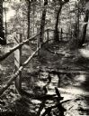
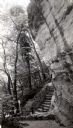
| Date: | 1945 |
|---|---|
| Description: | Tower Hill State Park trail to the top of the shot tower shaft. |
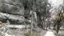
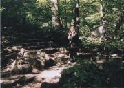
| Date: | 1963 |
|---|---|
| Description: | A trail leading into Parfrey's Glen in Devil's Lake State Park. Parfrey's Glen was Wisconsin's first State Natural Area in 1952. |

| Community: | Rock Springs |
|---|---|
| County: | Sauk |
| Historic Name: | Farmer's State Bank |
| Reference Number: | 136118 |
| Community: | Loganville |
|---|---|
| County: | Sauk |
| Historic Name: | Loganville State Bank |
| Reference Number: | 81030 |
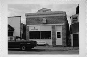
| Community: | Sauk City |
|---|---|
| County: | Sauk |
| Historic Name: | The State Bank |
| Reference Number: | 91461 |
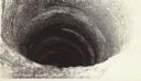
| Date: | |
|---|---|
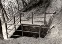
| Description: | The 120 foot shot shaft below the shot tower at Tower Hill State Park. |
| Community: | Baraboo |
|---|---|
| County: | Sauk |
| Historic Name: | Devil's Lake State Park |
| Reference Number: | 91125 |
| Date: | 1945 |
|---|---|
| Description: | Tower Hill State Park trail leading to the top of the shot tower shaft. |
| Community: | Baraboo |
|---|---|
| County: | Sauk |
| Historic Name: | Devil's Lake State Park-West Bluff Trail Sign |
| Reference Number: | 91119 |
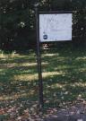
| Date: | 07 28 1943 |
|---|---|
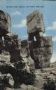
| Description: | Colorized postcard of the rock formation called Balanced Rock in Devil's Lake State Park. Foliage can be seen below and the sky is visible in the backgroun... |

| Date: | 06 04 1924 |
|---|---|
| Description: | Photographic postcard of rocks and trees above the lake in Devil's Lake State Park. Below on the left railroad tracks run along the shoreline. Trees and bl... |
| Date: | |
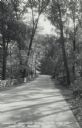
|---|---|
| Description: | Photographic postcard of the Warner Memorial Road in Devil's Lake State Park. Trees line both sides of the road, and there is a stone wall on the left. The... |
| Date: | |
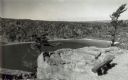
|---|---|
| Description: | A scenic view looking down at Devil's Lake from the bluffs of Devil's Lake State Park. A bench is in the right foreground. |

| Date: | 1920 |
|---|---|
| Description: | This map of Devil's Lake State Park in Sauk County, Wisconsin, shows the park limits, railroads, roads, creeks, trails, and points of interest in the area.... |
If you didn't find the material you searched for, our Library Reference Staff can help.
Call our reference desk at 608-264-6535 or email us at: