 Search: State
Filter: County of Vilas
Search: State
Filter: County of Vilas

| Community: | Presque Isle |
|---|---|
| County: | Vilas |
| Historic Name: | Presque Isle State Graded School |
| Reference Number: | 93000158 |

| Date: | |
|---|---|
| Description: | A man is standing outdoors next to a sign that reads: "Northern State Forest, State Forest Headquarters, District Forest Ranger, State Forest Nursery. Wisc... |
| Community: | |
|---|---|
| County: | Vilas |
| Historic Name: | Archaeological Site No. 47VI197 |
| Reference Number: | 94000816 |

| Date: | 1933 |
|---|---|
| Description: | This 1933 Wisconsin Conservation Dept. map shows roads, railroads, trails, lakes and streams, and the Trout Lake Game Refuge in Northern State Forest (whic... |
| Date: | |
|---|---|
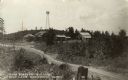
| Description: | View towards a group of buildings across a road, housing state forestry offices, stables and storage. A watchtower is on a hill. Caption reads: "State Fore... |

| Date: | 1912 |
|---|---|
| Description: | View of the main building at the Headquarters Camp State Board of Forestry at Trout Lake. This was the Headquarters of Field Instruction for Forest Ranger ... |

| Date: | 1911 |
|---|---|
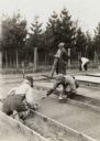
| Description: | Elevated view of garden plots at the state nursery at Trout Lake. Young pines must be grown for two years in the nursery before being planted. In this phot... |

| Date: | |
|---|---|
| Description: | View of the nursery. There is a fence along the side of the field in the background, and trees beyond. Caption reads: "Nursery; Wis. State Forest Reserve, ... |

| Date: | 02 1937 |
|---|---|
| Description: | This topographical map of the forest preserve shows highways, roads, trails, telephone lines, Native American reservations, Ranger sub-stations, state nurs... |

| Date: | 06 1960 |
|---|---|
| Description: | Historic Sites Committee, State Historical Society Annual Meeting. Members featured from left to right include: Carl Guell, State Aeronautics Commission, T... |

| Community: | St. Germain |
|---|---|
| County: | Vilas |
| Historic Name: | ST. GERMAIN STATE GRADED SCHOOL |
| Reference Number: | 24503 |
| Community: | Presque Isle |
|---|---|
| County: | Vilas |
| Historic Name: | Presque Isle State Graded School |
| Reference Number: | 44267 |

| Date: | 1926 |
|---|---|
| Description: | This Wisconsin Conservation Commission map from the 1920s shows roads, railroads, campsites, lookout towers, and privately owned lands in Northern Forest S... |

| Date: | 1907 |
|---|---|
| Description: | Text on front reads: "State Forest Reserve, Trout Lake, Wis." A two-story log building with a rubble stone foundation. The porch and stairs have ornate pin... |
| Date: | |
|---|---|
| Description: | Planting seedings at the state nursery at Trout Lake. |
| Community: | St. Germain |
|---|---|
| County: | Vilas |
| Historic Name: | |
| Reference Number: | 24486 |
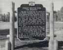
| Date: | 1963 |
|---|---|
| Description: | A Wisconsin state official historical marker titled 'Forest Restoration, The Beginning.' The text reads: "This place on Trout Lake was selected by E.M. G... |

| Date: | 1935 |
|---|---|
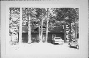
| Description: | A single lane unpaved road is winding through a wooded area of pine, birch, and other trees. |

| Wisconsin Historical Society, State Historic Preservation Office |
|---|
| Provides tax exemption for a property that contains an archaeological site listed in the National Register or State Register of Historic Places. |

| Date: | 2006 |
|---|---|
| Description: | This map includes indexed advertisements and map of the Lac du Flambeau region on back. The map is broken into 9 zones, each marked with state and club tra... |
If you didn't find the material you searched for, our Library Reference Staff can help.
Call our reference desk at 608-264-6535 or email us at: