Search: Wisconsin
Search: Conservation
Search: Department
Filter: Subject of land
Search: Wisconsin
Search: Conservation
Search: Department
Filter: Subject of land

| Date: | 04 1932 |
|---|---|
| Description: | This Wisconsin Conservation Department map shows federal, state, and county forest areas, the relative proportion of land owned by each agency, and state p... |

| Date: | |
|---|---|
| Description: | Wisconsin Conservation Warden checking on beaver traps. |

| Date: | |
|---|---|
| Description: | Wisconsin wardens patrolling waters of Wisconsin in a canoe. |

| Date: | 1936 |
|---|---|
| Description: | This 1936 Wisconsin Conservation Dept. map shows the locations of state forestry Civilian Conservation Corps (CCC) camps, closed state forestry CCC camps, ... |

| Date: | 11 23 1949 |
|---|---|
| Description: | Elevated view of a field, with farmland, roads, houses, and groves of trees. |

| Date: | 1952 |
|---|---|
| Description: | This Wisconsin Conservation Dept. map shows sections, roads, rivers, and lakes in the Town of Cloverland, Vilas County, Wisconsin as of February, 1952. It ... |

| Date: | 1952 |
|---|---|
| Description: | This Wisconsin Conservation Dept. map shows sections, roads, rivers, and lakes in the Town of Presque Isle, Vilas County, Wisconsin as of March 1953. It do... |

| Date: | 1937 |
|---|---|
| Description: | "Prepared ... March 1937." Includes location map. "State of Wisconsin, Conservation Department, Map Division"--upper left. From the E.P. Sherry papers rela... |

| Date: | 1935 |
|---|---|
| Description: | A sand dune in Point Beach State Forest has engulfed several trees. Two dead trees are standing in the foreground. |

| Date: | 1940 |
|---|---|
| Description: | A biplane is dropping fingerling fish into a Wisconsin lake. There are two small sheds on the shoreline. The caption on the reverse of the print reads: "Fi... |
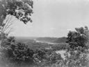
| Date: | 1935 |
|---|---|
| Description: | Elevated view, looking north, from Mt. Hosmer, with tall bluffs on the far (Wisconsin) side of the Mississippi River. There are multiple sloughs and island... |

| Date: | 09 26 1945 |
|---|---|
| Description: | Elevated view of Peninsula State Park. |
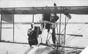
| Date: | 1915 |
|---|---|
| Description: | Jack Vilas (seated) in the Curtiss hydroplane he used to spot forest fires for the Wisconsin Conservation Department. (His companion is not identified.) Th... |
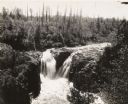
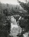
| Date: | |
|---|---|
| Description: | Elevated view of Copper Falls on the Bad River. Four people, one man and three women, are posing on rocks at the top of the falls. Surrounding burned-over ... |
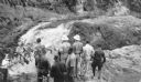
| Date: | 08 1940 |
|---|---|
| Description: | Elevated view of a group of Georgia Junior Rangers and their guides viewing the Copper Falls of the Bad River. |
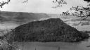
| Date: | 06 1936 |
|---|---|
| Description: | Caption reads: "Perrot State Park (Trempealeau vicinity), Wis. Mount Trempealeau, as seen from Brady's Bluff. View looking west. Photo by the Wisconsin Con... |
If you didn't find the material you searched for, our Library Reference Staff can help.
Call our reference desk at 608-264-6535 or email us at: