 Search: apostle
Search: islands
Filter: Subject of land
Filter: Subject of apostle islands
Search: apostle
Search: islands
Filter: Subject of land
Filter: Subject of apostle islands
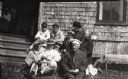
| Date: | 1910 |
|---|---|
| Description: | Group of men, women, and children seated on a bench and on the ground outside the Hermitage (Cedar Bark Lodge) on Hermit Island (Wilson Island). Included a... |
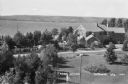
| Date: | 1937 |
|---|---|
| Description: | Elevated view of a woman standing on lawn of the Woods mansion on Nebraska Row. Bayfield is visible on the opposite mainland shore of Lake Superior. |
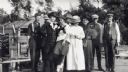
| Date: | 1913 |
|---|---|
| Description: | Group of men and women standing on a dock at Devils Island. From left to right are Nelson Angus, A.G. Hull, Elsie Tough (Kansas City), Anne Ashley, Mrs. Hu... |
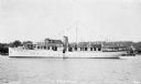
| Date: | 1933 |
|---|---|
| Description: | View across water of the motor yacht "The Nellewood" at dock at Madeline Island on Lake Superior. A group of passengers sit in the bow area. The "Nellewood... |

| Date: | 1871 |
|---|---|
| Description: | This map shows railroads, canals, towns and some lighthouses. Areas of the company lands proper, tin, iron, gold & silver, silver islet, and lead are color... |

| Date: | 1845 |
|---|---|
| Description: | This map shows lakes, rivers, Chippewa land, the U.S. Mineral Land Agency, boundary between U.S. and Canada, Methodist and Catholic missions, and American ... |
If you didn't find the material you searched for, our Library Reference Staff can help.
Call our reference desk at 608-264-6535 or email us at: