 Search: apostle
Search: islands
Filter: Subject of superior, lake
Search: apostle
Search: islands
Filter: Subject of superior, lake
| Date: | |
|---|---|
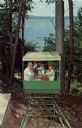
| Description: | Photographic postcard view of three people on the hillside lift at Chateau Madeleine. Lake Superior is at the bottom of the hill. Text on back reads: "Summ... |
| Date: | 1913 |
|---|---|
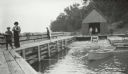
| Description: | Boathouse, dock and boat at Devils Island Light Station. Bill Baker, Elsie Tough, and Captain Angus. |
| Date: | 1917 |
|---|---|
| Description: | Group of men and women standing on Basswood Island Dock. Bill Baker, Elizabeth Hull, Florence Baker, Dorothy Stickney Ross, Louise Baker, Hamilton N. Ross ... |
| Date: | 1937 |
|---|---|
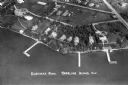
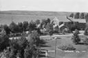
| Description: | Aerial view of Nebraska Row on the lakeshore of the west side of La Pointe, showing houses, roads and piers. Nebraska Row was started in 1899 when summer r... |
| Date: | 1920 |
|---|---|
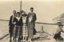
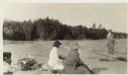
| Description: | View of Mrs. Cora Hull and Mrs. Julia Wood sitting on the beach at a shoreline. A man stands near the water. In the background are trees. |
| Date: | 1913 |
|---|---|
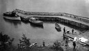
| Description: | Elevated view of wooden boats at Raspberry Island (or Devils Island) dock with picnickers on shore. The "Lizzie W' and Nelson Angus, A.G. Hull, Elsie Tough... |
| Date: | 1920 |
|---|---|
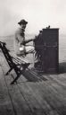
| Description: | Leo Capser, founder of the Madeline Island Historical Museum, sitting on a bench playing piano on the Old Mission Dock at Madeline Island. |
| Date: | 1937 |
|---|---|
| Description: | Elevated view of a woman standing on lawn of the Woods mansion on Nebraska Row. Bayfield is visible on the opposite mainland shore of Lake Superior. |
| Date: | 1913 |
|---|---|
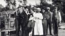
| Description: | Group of men and women standing on a dock at Devils Island. From left to right are Nelson Angus, A.G. Hull, Elsie Tough (Kansas City), Anne Ashley, Mrs. Hu... |
| Date: | 1933 |
|---|---|
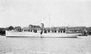
| Description: | View across water of the motor yacht "The Nellewood" at dock at Madeline Island on Lake Superior. A group of passengers sit in the bow area. The "Nellewood... |

| Date: | 1871 |
|---|---|
| Description: | This map shows railroads, canals, towns and some lighthouses. Areas of the company lands proper, tin, iron, gold & silver, silver islet, and lead are color... |

| Date: | 1845 |
|---|---|
| Description: | This map shows lakes, rivers, Chippewa land, the U.S. Mineral Land Agency, boundary between U.S. and Canada, Methodist and Catholic missions, and American ... |
If you didn't find the material you searched for, our Library Reference Staff can help.
Call our reference desk at 608-264-6535 or email us at: