 Search: apostle
Search: islands
Filter: Subject of superior, lake
Search: apostle
Search: islands
Filter: Subject of superior, lake

| Date: | |
|---|---|
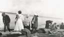
| Description: | Three women stand on the shore in front of the steamer Barker at Devils Island natural dock. |

| Date: | |
|---|---|
| Description: | Text on reverse reads: "Chateau Madeleine La Pointe, Wisconsin Summer and Fall Resort on Madeline Island (Apostle Islands) in Lake Superior. The Chateau's... |
| Date: | 1915 |
|---|---|
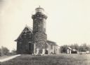
| Description: | Sand Island Lighthouse on Apostle Island, Lake Superior. Lighthouse keeper and family are posing in the front of the building. |

| Date: | 1884 |
|---|---|
| Description: | A detailed, hand-colored map of Wisconsin and the western portion of Michigan’s Upper Peninsula, which also includes an inset of Isle Royale in Lake Superi... |

| Date: | 1909 |
|---|---|
| Description: | This 1909 chart of the Apostle Islands, Chequamegon Bay, and the Lake Superior shoreline shows relief by contours and spot heights and depths by contours, ... |
| Date: | 1916 |
|---|---|
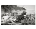
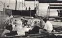
| Description: | Picnic on the shores of Basswood Island, Apostle Islands. Those picnicking include Harriet Webb, C.A. Hull, H.W. Rodgers, Mrs. J. Austin, Elizabeth Baker, ... |
| Date: | 1916 |
|---|---|
| Description: | Group of people gathered for a rustic picnic on Bear Island, Apostle Islands, Lake Superior. Image includes Mrs. J.L. Abernathy, Cora A. Hull, Mrs F.B. Chu... |
| Date: | 1916 |
|---|---|
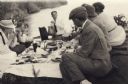
| Description: | Group having a picnic on Bear Island of the Apostle Islands. Group includes Cora A. Hull, Mrs. Chute, John Webb, Bob Webb, Mrs. Webb, Mrs. Austin, and Mr. ... |
| Date: | 08 22 1916 |
|---|---|
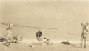
| Description: | Group setting up for a picnic at the shoreline on Bear Island of the Apostle Islands. Image includes A.G. Hull, Elizabeth Nisbet (Mrs. S.C. Marty Sr.), Eli... |

| Date: | |
|---|---|
| Description: | Exterior of the menu for Paul's Cafe, with a bird's-eye view map of "Washburn's Natural Deep Water Land Locked Harbor," Chequamegon Bay, and the Apostle Is... |

| Date: | 07 2001 |
|---|---|
| Description: | David Obey poses with Park Ranger Geoffrey Smith on the left and Martin Hanson on the right. They are standing on the beach with water and land in the back... |
| Date: | 1950 |
|---|---|
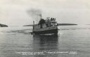
| Description: | Photographic postcard view of a fishing boat in Lake Superior with tourists on board. There is an island on the horizon. Caption reads: "'The Apostle Isla... |
| Date: | 1907 |
|---|---|
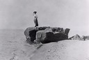
| Description: | Woman standing on soldier's rock on Madeline Island. |

| Date: | 1990 |
|---|---|
| Description: | This tourism brochure of Ashland County, Wisconsin, from the Ashland Area Chamber of Commerce includes a map of the county showing tourist destinations and... |
| Date: | 1934 |
|---|---|
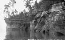
| Description: | View from water of sandstone cliffs and caves on Lake Superior shoreline. |
| Date: | |
|---|---|
| Description: | Group having a picnic on the shore of an Apostle Island. There is a large sailboat behind the group. |
| Date: | |
|---|---|
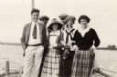
| Description: | Group of six young men and women standing on dock of an Apostle Island. |

| Date: | 1916 |
|---|---|
| Description: | This map is mounted on cloth and shows lots and roads. An inset map is included that shows towns, lakes, rivers, and railroads within portions of the Dakot... |
| Date: | 1918 |
|---|---|
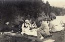
| Description: | C.A. Hull, an unidentified person, and Mason L. Thompson on an Apostle Island beach for a picnic. |

| Date: | 1906 |
|---|---|
| Description: | This map shows bays, creeks, railroads and rivers. Relief is shown by contours and spot heights. Depths are shown by contours, tints, and soundings. Includ... |
If you didn't find the material you searched for, our Library Reference Staff can help.
Call our reference desk at 608-264-6535 or email us at: