 Search: automobile
Search: industry
Filter: Year of 1900-1999
Filter: Subject of fishing
Search: automobile
Search: industry
Filter: Year of 1900-1999
Filter: Subject of fishing

| Date: | 08 1953 |
|---|---|
| Description: | Advertising proof created by Young and Rubicam for the International Harvester Company. Features an illustration of a swordfish being reeled in by men on a... |
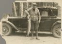
| Date: | 1933 |
|---|---|
| Description: | Outdoor portrait of a man wearing boots, pants, shirt, sweater and hat holding a large fish by its gills while standing in front of an automobile. |

| Date: | 1973 |
|---|---|
| Description: | Three-quarter view from front right of two tone, (flame red with white) pickup with open truck bed parked in the grass. In the background a man is fishing ... |

| Date: | 1961 |
|---|---|
| Description: | View of Scout parked on rocky shoreline. A man is walking near the Scout carrying a fishing pole and a large fish on a stringer. A fishing pole is sticking... |

| Date: | 1976 |
|---|---|
| Description: | This colored map displays Wisconsin and portions of bordering states, including a detailed map of the Wisconsin Dells area. Surrounding the map are multipl... |

| Date: | 1966 |
|---|---|
| Description: | This colored road map shows automobile roads in Wisconsin as well as portions of nearby states. A map key indicates relative sizes of cities and towns. On ... |

| Date: | 1975 |
|---|---|
| Description: | This colored road map of Wisconsin displays "Featured Points of Interest" and "Historical Points of Interest" in the state, including three color photograp... |

| Date: | 1907 |
|---|---|
| Description: | Outdoor group portrait of the Madison Branch of the Madison Saddlery Company located at 313-317 E. Wilson Street. The event may be a recreational gathering... |
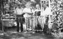
| Date: | 1920 |
|---|---|
| Description: | Three men and a woman pose with a pole of a stringer of fish. One of the men holds his pet dog. Behind them on the left is a bathtub, hand-pump for water, ... |
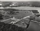
| Date: | 1950 |
|---|---|
| Description: | Aerial view of Northernaire Resort, on Deer Lake. The resort is in the foreground. Many lakes, surrounded by trees, are in the background, including Big St... |

| Date: | 1976 |
|---|---|
| Description: | This color map displays Wisconsin and bordering areas of Iowa, Minnesota, Illinois, and Michigan. At the bottom is a map key indicating road classification... |

| Date: | 1930 |
|---|---|
| Description: | Pictorial map of Glacier National Park, Montana and Waterton Lakes National Park, Alberta. Illustrated by Joe Scheurle, it depicts white people, American ... |

| Date: | 1976 |
|---|---|
| Description: | A man and a woman are standing in the grass near a small body of water and a white colored Scout II XLC. Near the parked vehicle is a red tent and a chair ... |

| Date: | 1916 |
|---|---|
| Description: | This map shows the locations of hunting and fishing resorts in the northern Wisconsin counties of Forest, Iron, Oneida, and Vilas, and in Gogebic County in... |

| Date: | 09 25 1937 |
|---|---|
| Description: | After a long day of fishing, the governors of three states are posing with ten muskies hanging from a birch log wired to two trees. Known as the "Battle of... |

| Date: | 02 04 1963 |
|---|---|
| Description: | International Scout De Luxe Camper promotional image. A woman is standing at the open back door pouring a cup of coffee. A man is looking up at her while w... |

| Date: | 1972 |
|---|---|
| Description: | This colored map displays Wisconsin and bordering areas of Iowa, Minnesota, and Michigan. There is color-coding on the map to indicate National Forests, an... |

| Date: | 1970 |
|---|---|
| Description: | This colored map displays detailed maps of Green Bay, Appleton, Racine, Milwaukee, Kenosha, and Duluth-Superior. At the top right is a map location list of... |

| Date: | 1973 |
|---|---|
| Description: | This map displays, in color, Wisconsin and bordering areas of Iowa, Minnesota, Illinois, and Michigan. At the bottom is a map key indicating road classifi... |

| Date: | 1977 |
|---|---|
| Description: | This colored map displays Wisconsin and portions of bordering states, including a detailed map of the Wisconsin Dells area. Surrounding the map are multipl... |
If you didn't find the material you searched for, our Library Reference Staff can help.
Call our reference desk at 608-264-6535 or email us at: