 Search: campaign
Filter: Subject of lakes
Search: campaign
Filter: Subject of lakes
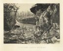
| Date: | 1866 |
|---|---|
| Description: | Cliffs along Lu-la Lake. A waterfall is in the background. Plate 15 |

| Date: | 1950 |
|---|---|
| Description: | This map shows regions in Northern Illinois and Southern Wisconsin roughly bounded by Lake Winnebago, the Kankakee River, Peoria, and Prairie du Chien. The... |

| Date: | 07 30 1954 |
|---|---|
| Description: | Cub Scouts roasting marshmallows with Aleen Plater, United Givers' Division head. Left to right: Mrs. Plater, Steve Plater, Joey MacDonald, Larry Frohmade... |

| Date: | 1979 |
|---|---|
| Description: | View of the sunken Statue of Liberty created by legendary University of Wisconsin student Leon Varjian. |

| Date: | 02 28 1963 |
|---|---|
| Description: | Three U.W. students, Marty Christensen, Robert Falconer and Gary Schroeder, jumped out of an airplane over ice-covered Lake Mendota to advertise the politi... |

| Date: | 02 1979 |
|---|---|
| Description: | View of the forehead and torch of a replica of the Statue of Liberty installed by the Pail and Shovel Party on the snow-covered ice of Lake Mendota. Text o... |

| Date: | 1795 |
|---|---|
| Description: | Map of the United States east of the Mississippi River. It features roads, cities, towns, early settlements, Native American land, forts, mountains, rivers... |

| Date: | 1780 |
|---|---|
| Description: | Detailed topographical and political map of the area from Lake Champlain to Albany and the Hudson River. Relief is shown through hachures. The map shows ci... |
If you didn't find the material you searched for, our Library Reference Staff can help.
Call our reference desk at 608-264-6535 or email us at: