 Search: davis
Filter: Subject of water
Filter: Year of 1800-1899
Search: davis
Filter: Subject of water
Filter: Year of 1800-1899

| Date: | 1830 |
|---|---|
| Description: | Fort Winnebago from an original drawing by Jefferson Davis. |
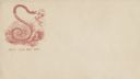
| Date: | 1860 |
|---|---|
| Description: | Jefferson Davis, wearing his nightshirt with rumpled hair, is recoiling from a large snake. The snake's tongue is touching Davis' nose. A marsh appears in ... |
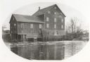
| Date: | 1885 |
|---|---|
| Description: | Lemonweir River flour mill built in 1852 and torn down in 1943. Mill and site were purchased in 1926 by the Wisconsin Power and Light Company for a power p... |
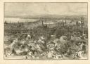
| Date: | 1882 |
|---|---|
| Description: | Bird's-eye view of Milwaukee looking south down 8th Street from Schlitz's Park. |
| Date: | 1860 |
|---|---|
| Description: | Jefferson Davis walks a tightrope over a waterfall heading toward the side of a cliff on which is the Capitol building, a soldier, and the Union flag. Behi... |
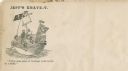
| Date: | 1860 |
|---|---|
| Description: | Jefferson Davis and six sailors sail in a tea cup. A pirate flag flies overhead. One sailor is in the "crow's nest." Another is using a paddle. Three sailo... |

| Date: | 1880 |
|---|---|
| Description: | This map is pen-and-ink on paper. The map shows buildings, trees, and water and gas pipes, relief is shown by contours. The back of the map reads: "Univers... |

| Date: | 1859 |
|---|---|
| Description: | This map show plats including plat names, plat numbers, and some lot owner's names. Relief is shown by hachures. The map includes line drawings of Juneau B... |
If you didn't find the material you searched for, our Library Reference Staff can help.
Call our reference desk at 608-264-6535 or email us at: