 Search: electric
Search: power
Filter: Categories of Wisconsin Historical Images
Filter: Type of Map or Atlas
Search: electric
Search: power
Filter: Categories of Wisconsin Historical Images
Filter: Type of Map or Atlas
| Date: | 1934 |
|---|---|
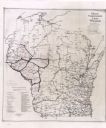
| Description: | This map shows the electric transmission lines, cities, and county boundaries. Includes a list of holding groups and operating companies. Caption reads: "M... |

| Date: | 1910 |
|---|---|
| Description: | This map shows railroads, counties, cities and villages, rivers, lakes, and electric lines are shown in Wisconsin, the western portion of Michigan's Upper ... |
| Date: | |
|---|---|
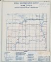
| Description: | Rural electrification survey map of Marquette county in Westfield township. |
| Date: | |
|---|---|
| Description: | Rural electrification survey map of Waushara county in Springwater township. |
| Date: | 06 1975 |
|---|---|
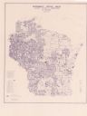
| Description: | This map shows electrical utilities and cooperatives throughout the state, as well as cities and county boundaries. The bottom left corner of the map inclu... |

| Date: | 1918 |
|---|---|
| Description: | This map shows counties, cities, towns, villages, summer resorts, lakes, rivers, creeks, wagon roads, roads, railroads, and electric lines. The authentic a... |
| Date: | |
|---|---|
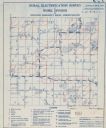
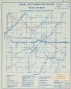
| Description: | Rural electrification map of Dodge county in Elba township. Title at top reads: "Rural Electrification Survey by Work Division of Wisconsin Emergency Relie... |

| Date: | 1970 |
|---|---|
| Description: | This map shows colored-coded land use with a legend in the bottom margin. Land classifications include: Year-round Residential (yellow), Seasonal Residenti... |

| Date: | 1915 |
|---|---|
| Description: | This map shows roads, railroads, street railways, abandoned logging railroads, rural mail routes, telephone lines, schools, platted land, and state forest ... |

| Date: | 1888 |
|---|---|
| Description: | This map has relief shown by hachures and features inset maps of a plat of E.D. Clinton and Blackwell’s add’n to the City of La Crosse. Wards (1-10) shaded... |
If you didn't find the material you searched for, our Library Reference Staff can help.
Call our reference desk at 608-264-6535 or email us at:
