 Search: increase
Search: lapham
Filter: Categories of Wisconsin Historical Images
Search: increase
Search: lapham
Filter: Categories of Wisconsin Historical Images
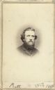
| Date: | 1864 |
|---|---|
| Description: | Vignetted carte-de-visite portrait of William H. Pratt of Davenport, Iowa. Handwritten inscription at bottom reads, "Pratt, 1864." |
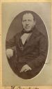
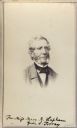
| Date: | |
|---|---|
| Description: | Carte-de-visite portrait of Franz Brandecke, Milwaukee-based geologist. Worked on Wisconsin geological survey with Lapham. Handwritten text on front read... |

| Date: | 1864 |
|---|---|
| Description: | This map shows locations of quarries, sink holes, creeks, springs, rivers, houses, forts, and roads. The upper right corner and right margin includes anno... |
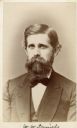
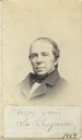
| Date: | 1872 |
|---|---|
| Description: | Carte-de-visite portrait of Professor W.W. Daniels, University of Wisconsin geologist. Daniels worked as one of Increase Lapham's assistants during the Wis... |
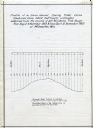
| Date: | 12 1860 |
|---|---|
| Description: | Graph showing the profile of a semi-diurnal spring tidal curve deduced from 5452 half hourly ordinates obtained from the records of self registering tide g... |

| Date: | 1837 |
|---|---|
| Description: | Map of the proposed route of the Milwaukee and Rock River Canal. |

| Date: | 1864 |
|---|---|
| Description: | This map is pen and watercolor on paper and shows a profile and geological sections of the Apple River, Little Otter Creek, Woods' Branch, Bonners' Branch,... |

| Date: | 1864 |
|---|---|
| Description: | Map showing locations of quarries, sink holes, creeks, springs, rivers, houses, forts, and roads. The map appears to have been drawn on to of a plat map of... |

| Date: | 1870 |
|---|---|
| Description: | This map is mostly pencil on paper map but includes latitude and longitude grid in ink. The map covers the Mississippi River from Lake Itasca to the Wiscon... |
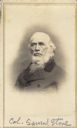
| Date: | |
|---|---|
| Description: | Vignetted carte-de-visite portrait of Colonel Samuel Stone (1798-1876), Massachusetts-born Union Colonel. Before his army service, Stone's various occupati... |
| Date: | 1865 |
|---|---|
| Description: | Vignetted carte-de-visite quarter-length portrait of John Torrey (1796-1863), American botanist. Worked as New York state botanist from 1836. Handwritten i... |

| Date: | 1845 |
|---|---|
| Description: | This map shows lot and block numbers, local streets, railroads, some landowners’ names, Milwaukee River, Menomonee River, and part of Lake Michigan. The ma... |

| Date: | 1864 |
|---|---|
| Description: | This map shows locations of quarries, sink holes, creeks, springs, rivers, houses, forts, and roads. Annotations in pencil read: "Is the top of the mound l... |

| Date: | 1851 |
|---|---|
| Description: | Diagram of an effigy mound in the shape of a cross. |

| Date: | 1864 |
|---|---|
| Description: | This map is pen and watercolor on paper and shows a profile and geological sections of the Blue Mounds, Hollow Run, Bogies Hollow Run, Bear Creek, East Bre... |

| Date: | 1864 |
|---|---|
| Description: | This map is pen and watercolor on paper and shows a profile and geological sections of the Spensley Break, James Break, Wisconsin River, and Little Bear Cr... |

| Date: | 1836 |
|---|---|
| Description: | Pencil on tracing paper. Rough sketch of Milwaukee. Left top corner reads: "From Map of northern part of Illinois and the surveyed part of Wisconsin Territ... |
| Date: | 1864 |
|---|---|
| Description: | Vignetted carte-de-visite portrait of Leo Lesquereux, American paleobotanist. Also worked as assistant to L. Aggasiz. |

| Date: | 1864 |
|---|---|
| Description: | This map is pen and watercolor on paper and shows profile and geological formation of Blue Mound and location of Arnold’s Hotel and Brigham Lead Mines. |

| Date: | 1864 |
|---|---|
| Description: | This map is pen and watercolor on paper and shows a profile and geological sections of the East Blue Mound Break, Blue Mound Creek, Black Earth River, and ... |
If you didn't find the material you searched for, our Library Reference Staff can help.
Call our reference desk at 608-264-6535 or email us at: