 Search: menominee
Filter: Year of 1800-1899
Filter: Subject of transportation
Search: menominee
Filter: Year of 1800-1899
Filter: Subject of transportation

| Date: | 1887 |
|---|---|
| Description: | A bird's-eye map of Menekaune, Menominee and Marinette. |

| Date: | 1887 |
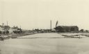
|---|---|
| Description: | The bay shore of Menominee filled with driftwood. |
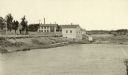
| Date: | 1887 |
|---|---|
| Description: | A view at the mouth of the Menominee River showing Ludington Wells and Van Schaick's mills. |

| Date: | 1899-03-09 |
|---|---|
| County: | Marinette |
| City: | Marinette |
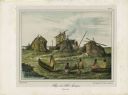
| Date: | 1842 |
|---|---|
| Description: | A Menominee village as depicted by Francois, Comte de Castelnau, a French naturalist and diplomat who visited the Green Bay area about 1838. The detailed, ... |
| Date: | 07 30 1865 |
|---|---|
| Description: | An exterior view across water of Robert Stephenson & Company Mill, which was a steam mill. |

| Date: | 10 21 1855 |
|---|---|
| Description: | Map of the Wisconsin and the Minnesota Territory showing the status of township surveys in Wisconsin and southeastern Minnesota. The Wisconsin reservation... |

| Date: | 1874 |
|---|---|
| Description: | This hand-colored map shows the railroads "completed" "in progress" and "contemplated" rivers, counties, cities and villages, and named towns in the state,... |

| Date: | 1835 |
|---|---|
| Description: | Little Lake Butte Des Morts just north of Lake Winnebago where Governor Lewis Cass of Michigan, and Thomas McKenney, head of the Bureau of Indian Affairs (... |
| Date: | 1887 |
|---|---|
| Description: | View of the boom company office and the site of the old trading post. |

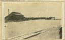
| Date: | 1887 |
|---|---|
| Description: | Mill workers in the yard at Ramsay & Jones Mill. |

| Date: | 1887 |
|---|---|
| Description: | The Ramsay & Jones Mill with logs in the water in the foreground. |

| Date: | 1855 |
|---|---|
| Description: | This Wisconsin map depicts counties, creeks, rivers, lakes, railroads completed, railroads in progress, common roads and the Menomonee Reservation. |

| Date: | 1855 |
|---|---|
| Description: | This map depicts counties, creeks, rivers, lakes, railroads completed, railroads in progress, common roads and the Menomonee Reservation. |

| Date: | 1862 |
|---|---|
| Description: | Drawn the second year of the Civil War, this 1862 map of Milwaukee shows post offices, light houses, beacon lights, county buildings, elevator warehouses, ... |

| Date: | 1855 |
|---|---|
| Description: | This map shows the entire state and part of the Upper Peninsula of Michigan. It depicts creeks, rivers, lakes, railroads completed, railroads in progress, ... |

| Date: | 1857 |
|---|---|
| Description: | This map depicts the township survey grid and identifies counties, named towns, cities and villages, rivers, lakes, railroads, roads, and the Menomonee and... |

| Date: | 1858 |
|---|---|
| Description: | This map of the entire state of Wisconsin depicts the township survey grid and identifies counties, named towns, cities and villages, rivers, lakes, railro... |

| Date: | 1878 |
|---|---|
| Description: | A hand-colored, cloth mounted, sectional map of Wisconsin and the western portion of Michigan’s Upper Peninsula, showing the township grid, railroads, town... |
If you didn't find the material you searched for, our Library Reference Staff can help.
Call our reference desk at 608-264-6535 or email us at: