Search: milwaukee
Filter: Year of 1800-1899
Filter: Year of 1850-1859
Search: milwaukee
Filter: Year of 1800-1899
Filter: Year of 1850-1859

| Date: | 1854 |
|---|---|
| Description: | Reproduction printed on glossy, cloth-backed paper. Right side includes "References," or points of interest that correspond to numbers on the map. Running ... |
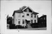
| Community: | West Bend |
|---|---|
| County: | Washington |
| Historic Name: | Milwaukee House |
| Reference Number: | 28796 |
| Community: | Cambridge |
|---|---|
| County: | Dane |
| Historic Name: | INN ON THE MADISON-MILWAUKEE OXEN ROUTE* |
| Reference Number: | 5286 |
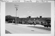
| Community: | Janesville |
|---|---|
| County: | Rock |
| Historic Name: | Chicago, Milwaukee and St. Paul Railroad Roundhouse |
| Reference Number: | 75918 |

| Community: | Milwaukee |
|---|---|
| County: | Milwaukee |
| Historic Name: | State Bank of Wisconsin (Bank of Milwaukee Block) |
| Reference Number: | 27221 |
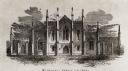
| Date: | 1852 |
|---|---|
| Description: | First building of Milwaukee College planned by Catherine E. Beecher. Front of building with gothic detailing in the architecture. |
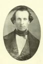
| Date: | 06 30 1855 |
|---|---|
| Description: | Certificate of appointment for George B. Bingham as 1st Lieutenant, Milwaukee Light Guards. |

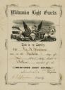
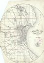
| Date: | 1853 |
|---|---|
| Description: | Plan no. 3. Scale 2000 feet to one inch. |

| Date: | 1858 |
|---|---|
| Description: | Map of Martineau's Addition in the first ward of Milwaukee as well as buildings and location of adjacent additions with landowners names. |

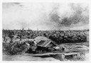
| Date: | 1854 |
|---|---|
| Description: | Bird's-eye illustration of Milwaukee. |

| Date: | 08 1852 |
|---|---|
| Description: | Pencil drawing of Milwaukee Harbor with large sailboats on the water. In the minimalist depiction the sandy shoreline with short plant growth sweeps aroun... |
| Date: | 06 1858 |
|---|---|
| Description: | This map shows additions and subdivisions to Milwaukee, city wards, roads, railroads, and selected buildings. This map was engraved to accompany the city d... |
| Date: | 1850 |
|---|---|
| Description: | An illustration of the Old North Pier landing on Huron Street, drawn from memory. |

| Date: | 1854 |
|---|---|
| Description: | This map shows lot and block numbers, roads, railroads, and some landowners’ names. Lake Michigan, the Milwaukee River, and the Menomonee River are labeled... |

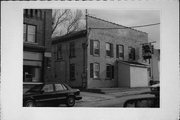
| Community: | Milwaukee |
|---|---|
| County: | Milwaukee |
| Historic Name: | |
| Reference Number: | 100622 |
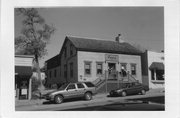
| Community: | Milwaukee |
|---|---|
| County: | Milwaukee |
| Historic Name: | |
| Reference Number: | 98287 |
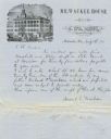
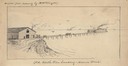
| Date: | 1857 |
|---|---|
| Description: | Letter on stationery featuring an engraving of an exterior view of the Milwaukee House showing horse-drawn vehicles and people standing on the sidewalk in ... |

| Date: | 1856 |
|---|---|
| Description: | This map shows lot and block numbers, wards, roads, railroads, and some landowner names. Lake Michigan and the Milwaukee River are labeled. Includes an ins... |
If you didn't find the material you searched for, our Library Reference Staff can help.
Call our reference desk at 608-264-6535 or email us at: