 Search: mounds
Filter: Categories of Wisconsin Historical Images
Filter: Subject of lakes
Search: mounds
Filter: Categories of Wisconsin Historical Images
Filter: Subject of lakes

| Date: | 1941 |
|---|---|
| Description: | The typed caption on the reverse of this photograph explains: "On the bridge above the underground lake in Cave of the Mounds at Blue Mounds, Wis., Arthur ... |

| Date: | 1916 |
|---|---|
| Description: | In 1916, it was estimated that 15,000 Indian mounds had formerly existed in Wisconsin. In the early 20th century, the Wisconsin Archaeological Society surv... |

| Date: | 1920 |
|---|---|
| Description: | Two cottages at Burgy Mounds on Lake Koshkonong. |

| Date: | |
|---|---|
| Description: | Three separate maps: Ancient Works Near Manitowoc (surveyed 1850), Ancient Works on the North Side of Lake Wingra (surveyed 1850), and Mounds at Madison (s... |
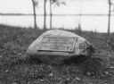
| Date: | |
|---|---|
| Description: | View of a rock with a plaque that reads: "Group of Prehistoric Indian Burial Mounds and Winnebago Village Site. Marked by the Delavan Woman's Club - May 19... |

| Date: | |
|---|---|
| Description: | View of burial mounds in a park on the edge of a lake. Caption reads: "Indian Burial Grounds in Wakanda Park, Menomonie, Wis." |

| Date: | 1941 |
|---|---|
| Description: | This pictorial map shows sites related to Indian legends, mounds, and trails in the Chain O' Lakes region in southwestern Waupaca County, Wisconsin. |

| Date: | 1892 |
|---|---|
| Description: | This map oriented with north to the upper left shows railroads, creeks, post offices, smaller lakes, Lake Mendota, Lake Monona, Lake Wingra, Lake Waubesa, ... |

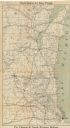
| Date: | 1931 |
|---|---|
| Description: | This map of south central Wisconsin shows lakes, rivers, cities, villages, highways and roads, railroads, Indian mounds, and points of scenic and historic ... |

| Date: | 1920 |
|---|---|
| Description: | View from shore of a group of men posing on a dock at Burgy Mounds on Lake Koshkonong. Boats are tied to the dock. There are a number of people in boats fa... |

| Date: | 1919 |
|---|---|
| Description: | Narrow red lines show principal secondary highways. Green circles shows points of historical interest. Green triangles show Indian mounds and Indian villag... |

| Date: | 1861 |
|---|---|
| Description: | This map shows townships and sections, landownership, roads, railroads, rural residences, schools, churches, and topography. Also included are inset maps o... |

| Date: | 1892 |
|---|---|
| Description: | Topographical map of Madison and surrounding communities which include Lake Mendota, Lake Monona, Lake Waubesa and Lake Kegonsa. The red dots on the map sh... |

| Date: | 1849 |
|---|---|
| Description: | Published in Germany a year after Wisconsin entered statehood, this map shows prairies, swamps, lakes, mounds, limestone deposits, and lead and copper mine... |

| Date: | 1974 |
|---|---|
| Description: | This 1974 map is a reproduction of the original survey maps of the Four Lakes region of Dane County, Wisconsin. It shows sections, lakes, rivers, wetlands,... |

| Date: | 1927 |
|---|---|
| Description: | Blueprint-style map of Frost Woods on the shore of Lake Monona. The map indicates the locations of Indian mounds, an Indian camp, and various plants. There... |
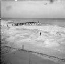
| Date: | 1905 |
|---|---|
| Description: | Elevated winter scene with Sylvester Dankoler (b. 1895) standing on ice and mounds of snow near a broken pier along a shoreline. The shadow of the photogra... |

| Date: | 1859 |
|---|---|
| Description: | Shows townships and sections, landownership, roads, railroads, rural residences, schools, churches, and topography. Relief shown by hachures. "From governm... |

| Date: | 1924 |
|---|---|
| Description: | A map of the Madison Township, T7N R9E including Lake Mendota showing the location of Ho Chunk encampments and effigy mounds. |
| Date: | 1909 |
|---|---|
| Description: | This map shows the Chicago and North Western Railway lines in eastern Wisconsin, north to Wausau and Oconto and west to Baraboo and Blue Mounds, and northe... |
If you didn't find the material you searched for, our Library Reference Staff can help.
Call our reference desk at 608-264-6535 or email us at: