 Search: mounds
Filter: Community of Madison
Search: mounds
Filter: Community of Madison

| Date: | 05 05 1939 |
|---|---|
| Description: | Charles E. Brown poses near a historic tablet marking one of a row of conical burial mounds on the Park and Pleasure drive on the north shore of Lake Wingr... |

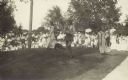
| Date: | 1910 |
|---|---|
| Description: | A sightseeing party wanders among cows and Native American burial mounds near the popular picnic area at Merrill Springs, on the south shore of Lake Mendot... |
| Date: | 1909 |
|---|---|
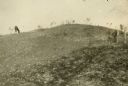
| Description: | A horse grazes near Native American burial mounds on the Dividing Ridge, a recessional moraine, between Lakes Monona and Wingra in Madison, Wisconsin. The ... |

| Date: | 1915 |
|---|---|
| Description: | A row of conical burial mounds adjoins the Park and Pleasure Drive on the north shore of Lake Wingra (now Edgewood Drive, at the south edge of Edgewood Col... |
| Date: | 1914 |
|---|---|
| Description: | Ceremony for erecting tablets on the Observatory Hill Mounds performed by University of Wisconsin summer session students. |

| Date: | 10 1911 |
|---|---|
| Description: | This map shows lot numbers, building lines, roads, trees, and Indian mounds. Relief is shown by contours. Includes manuscript annotations marking parks. |

| Date: | |
|---|---|
| Description: | Wisconsin Memorial Hospital with a key to buildings in the upper left. Indian mounds are marked on the site. Arthur Peabody was the state architect for th... |

| Date: | 1892 |
|---|---|
| Description: | This map oriented with north to the upper left shows railroads, creeks, post offices, smaller lakes, Lake Mendota, Lake Monona, Lake Wingra, Lake Waubesa, ... |
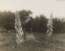
| Date: | 10 07 1914 |
|---|---|
| Description: | Sara (Mrs. Joseph) Mallon (Menominee) of Milwaukee, wearing a sash stands between two American flags behind a memorial that reads, "Indian Mounds: One of s... |
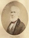
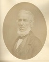
| Date: | 1856 |
|---|---|
| Description: | Quarter-length oval portrait of Ebenezer Brigham, founder of the first major community in the Blue Mounds of Wisconsin, which included a mine, frontier inn... |
| Date: | 1856 |
|---|---|
| Description: | Quarter-length oval portrait of Ebenezer Brigham, founder of the first major community in the Blue Mounds of Wisconsin, which included a mine, frontier inn... |

| Date: | 1974 |
|---|---|
| Description: | This 1974 map is a reproduction of the original survey maps of the Four Lakes region of Dane County, Wisconsin. It shows sections, lakes, rivers, wetlands,... |

| Date: | 1924 |
|---|---|
| Description: | A map of the Madison Township, T7N R9E including Lake Mendota showing the location of Ho Chunk encampments and effigy mounds. |
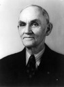
| Date: | |
|---|---|
| Description: | Quarter-length portrait of Charles E. Brown. Brown as an archeologist primarily responsible for saving more than one hundred Indian mounds from destruction... |
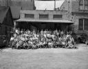
| Date: | 06 29 1948 |
|---|---|
| Description: | Group portrait of 110 Wisconsin State Journal paper carriers taken prior to leaving for Blue Mounds State Park for the annual all-day outing. |

| Date: | 07 25 1958 |
|---|---|
| Description: | View towards the exterior of a two-story addition to Hoyt School (on Regent Street near Hoyt Park). There are mounds of ground rubble near trees, and a car... |
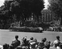
| Date: | 05 29 1948 |
|---|---|
| Description: | Wisconsin Centennial Parade near the Wisconsin State Capitol. The Blue Mounds float depicting Dane County's first settler, Ebenezer Brigham, is coming down... |

| Date: | 1924 |
|---|---|
| Description: | This pictorial map focuses on the Madison Isthmus, Lake Mendota, Lake Monona, Lake Wingra, and shows points of historical interest, buildings, parks, and I... |

| Date: | 1933 |
|---|---|
| Description: | Blue print and blue line print maps that show local streets, Nakoma Country Club, part of Lake Forest, and part of Lake Wingra. A legend is included that s... |

| Date: | |
|---|---|
| Description: | A large burial mound near the south side of Governor Nelson State Park. |
If you didn't find the material you searched for, our Library Reference Staff can help.
Call our reference desk at 608-264-6535 or email us at: