Search: mounds
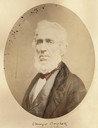
| Date: | 1856 |
|---|---|
| Description: | Quarter-length oval portrait of Ebenezer Brigham, founder of the first major community in the Blue Mounds of Wisconsin, which included a mine, frontier inn... |
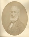
| Date: | 1856 |
|---|---|
| Description: | Quarter-length oval portrait of Ebenezer Brigham, founder of the first major community in the Blue Mounds of Wisconsin, which included a mine, frontier inn... |

| Date: | 1925 |
|---|---|
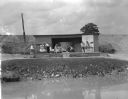
| Description: | Adams house and store. John Adams sold pork, flour, and other merchandise during mining days. Said to be the birthplace of Aliva Adams, afterwards the Gove... |
| Date: | |
|---|---|
| Description: | Black and white postcard of an indoor scene with a loom, spinning wheel, skeiner, garments and two dolls seated in a chair at Little Norway. |

| Date: | 1850 |
|---|---|
| Description: | Map showing Indian mounds and graves as well as ground cover types at Township 8, Range 22. There is an inset diagram of an effigy mound labeled "The Cross... |

| Date: | 1925 |
|---|---|
| Description: | This map shows trails, mounds, villages, corn fields, and contemporary civil townships; some villages and features include both Indian and English place na... |

| Date: | 04 28 2015 |
|---|---|
| Description: | View down a gravel path leading into a forest. The trees are bare of leaves, but the grass is green. A wood marker is at the intersection of a dirt path on... |

| Date: | 12 01 1962 |
|---|---|
| Description: | A farm road between fields in late sunlight, looking towards Mounds Creek in the vicinity of CTH F. |
| Date: | 07 31 1960 |
|---|---|
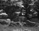
| Description: | A large rock formation in the schoolyard of the Deneen School. A small outbuilding and fence is visible in the background. |

| Date: | 1925 |
|---|---|
| Description: | A view looking up a winding road with rows of utility lines on both sides. The road is partially fenced. |

| Date: | 1962 |
|---|---|
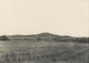
| Description: | Elevated view over wooded farmland valley. In the far distance on top of the hill are farm buildings. |

| Date: | 1920 |
|---|---|
| Description: | View from shore of a group of men posing on a dock at Burgy Mounds on Lake Koshkonong. Boats are tied to the dock. There are a number of people in boats fa... |

| Date: | 04 21 1911 |
|---|---|
| Description: | Group of men and a young boy breaking hemp at the Brigham farm. |

| Date: | 1840 |
|---|---|
| Description: | This map shows local streets, numbered lots, and part of Blue Mounds Branch. The map reads: "NE 1/4 NW 1/4 Sect. 16 - T5 - R5E." under the title and is dat... |

| Date: | 1955 |
|---|---|
| Description: | View across field of a dynamite explosion occurring between several mounds of dirt. A digger stands next to the dirt mound on the right. |

| Date: | 1861 |
|---|---|
| Description: | This map shows townships and sections, landownership, roads, railroads, rural residences, schools, churches, and topography. Also included are inset maps o... |

| Date: | 1919 |
|---|---|
| Description: | Narrow red lines show principal secondary highways. Green circles shows points of historical interest. Green triangles show Indian mounds and Indian villag... |

| Date: | |
|---|---|
| Description: | A vintage view and a modern view of buildings in the downtown area, presented as a pair. There is snow on the ground. The vintage view shows horses and wag... |
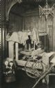
| Date: | 06 25 1948 |
|---|---|
| Description: | Crater Players on stage rehearsing for the play, "The Drunkard". Left to right are: organizer Professor Ronald E. Mitchell, Olaf Ussing, Josephine Bomgardn... |
If you didn't find the material you searched for, our Library Reference Staff can help.
Call our reference desk at 608-264-6535 or email us at: