 Search: people
Filter: Categories of Wisconsin Historical Images
Filter: Subject of maps
Search: people
Filter: Categories of Wisconsin Historical Images
Filter: Subject of maps

| Date: | |
|---|---|
| Description: | Former President Jimmy Carter addressing a crowd of people in a classroom. Vel Phillips is on the far left standing next to the President. A group of peopl... |

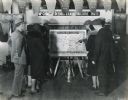
| Date: | 1962 |
|---|---|
| Description: | A group of people are working at a table on the left in a showroom. On display are tractors and a harvester. A large map of the world is on the wall in the... |

| Date: | 09 03 1938 |
|---|---|
| Description: | A group of people at the Indiana State Fair gather around a map of Indiana showing locations for the manufacture of International truck parts. The Internat... |

| Date: | 08 1971 |
|---|---|
| Description: | Poster advertising for an event occurring between August 1971 and February 1972 called the "Traffic Experiment," in Madison. Features screen printed silhou... |

| Date: | 07 01 1954 |
|---|---|
| Description: | Two young people are examining a wall chart depicting traffic lanes, cross walks, and intersections. There are movable adhesive rectangles representing car... |

| Date: | 01 16 1959 |
|---|---|
| Description: | Several people looking at a topographical model of Bascom Woods and Muir Knoll by the surrounding buildings between Elizabeth Waters Hall, the Carillon Tow... |
| Date: | 1931 |
|---|---|
| Description: | A group of people look at an 1831 United States map, part of a McCormick-Deering milking machine parts display. The title on the map reads, "The United St... |
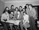
| Date: | 05 02 1950 |
|---|---|
| Description: | Group portrait of young people from the Madison area who will travel together in Europe this summer. Standing, left to right: Helen Olson, Charles Sharpe, ... |
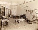
| Date: | 1893 |
|---|---|
| Description: | Interior of the State School for the Blind, perhaps a study or room for recreation. Included in the room are several tables with small models, a piano, and... |

| Date: | 1918 |
|---|---|
| Description: | Propaganda poster encouraging American involvement in World War I by depicting the Prussian army as enslaving Europe. Includes a map of Europe with the lan... |

| Date: | |
|---|---|
| Description: | Wisconsin promotional decal with a map of the state, with many cities marked and drawings of some Wisconsin icons: cheese, cows, deer, beer, Wisconsin Dell... |
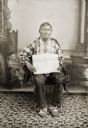
| Date: | |
|---|---|
| Description: | Full-length studio portrait of an elderly Ho-Chunk man posing sitting in front of a painted backdrop. Green Grass (HaWinChoKah) is wearing floral beaded Ho... |

| Date: | 1918 |
|---|---|
| Description: | Poster featuring a map of the near East, with countries demarcated. The poster title is red text reading: "Where the Victims Are." The rest of the text rea... |

| Date: | 1953 |
|---|---|
| Description: | Front and back of one-page menu from the Scandia Restaurant, with a whimsical cartoon map rendering by Hakon Mielche of the Scandinavian countries and the ... |
| Date: | 1893 |
|---|---|
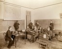
| Description: | Male and female students read and practice math at the State School for the Deaf as a teacher looks on from the head of the class. |

| Date: | 1933 |
|---|---|
| Description: | Map created by International Harvester entitled: "The United States as it appeared in 1831 when Cyrus Hall McCormick invented the Reaper." The map pinpoint... |

| Date: | 1982 |
|---|---|
| Description: | This map shows the location of major settlement regions for various ethnic groups. Includes a legend in lower left hand corner. Sparse settlement is repres... |

| Date: | 1627 |
|---|---|
| Description: | Map of North and South America showing settlements, rivers, lakes, mountains, islands and regions of the western hemisphere. It includes an inset map of Gr... |

| Date: | 1630 |
|---|---|
| Description: | One of the few maps by Dutch cartographer Willem Blaeu depicting the Americas, this map shows regions, settlements, islands, mountains, forests, rivers, an... |

| Date: | 1870 |
|---|---|
| Description: | Bird's-eye view of the city of Manitowoc with a population of 5,168 inhabitants as it appears in 1870, the year the village was granted a city charter by t... |
If you didn't find the material you searched for, our Library Reference Staff can help.
Call our reference desk at 608-264-6535 or email us at: