 Search: public
Filter: Type of Map or Atlas
Search: public
Filter: Type of Map or Atlas

| Date: | 1867 |
|---|---|
| Description: | Bird's-eye map of Berlin, with insets of West Side Public School and High School. |

| Date: | 1870 |
|---|---|
| Description: | Bird's-eye map of Hudson, with insets of Court House and Public School. |

| Date: | 1868 |
|---|---|
| Description: | Bird's-eye map of Portage, with insets of the Court House and the Public School. |

| Date: | 1874 |
|---|---|
| Description: | Bird's-eye map of Lodi, with inset of Public School. Includes index of churches and points of interest. |

| Date: | 1900 |
|---|---|
| Description: | This map is indexed and shows numbering system, public buildings and parks, wards, and voting booths. |
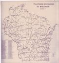
| Date: | 11 1973 |
|---|---|
| Description: | This map shows the cities, county boundaries and telephone exchange locations. The map includes a numbered list of telephone companies. |

| Date: | 1935 |
|---|---|
| Description: | This three-part map from the U.S. Bureau of Public Roads identifies highways in Wisconsin that have been improved, indicating those which are federal highw... |

| Date: | 1850 |
|---|---|
| Description: | This map of Geneva shows lots and acreages, reserved land, and public squares. Streets and Lake Geneva are labeled. The map includes manuscript annotations... |

| Date: | 1900 |
|---|---|
| Description: | This map includes an index of streets and schools, and shows parks and public lands, as well as industrial sites. |

| Date: | 1925 |
|---|---|
| Description: | This map shows the public schools and their school districts. The bottom of the map reads:" Old buildings and sites in red. New buildings and sites in blac... |

| Date: | 1960 |
|---|---|
| Description: | This map shows improved town roads, federal highways, county highways, public boat access, public hunting areas, railroads, and lakes in the area around th... |

| Date: | 1882 |
|---|---|
| Description: | This map is ink and watercolor on paper and shows numbered plots, the public square, streets, Lake St. Croix and the Mississippi River. |
| Date: | 1974 |
|---|---|
| Description: | This blue line map show gas services and county boundaries. Includes a legend of company names in lower left hand corner. |
| Date: | 1961 |
|---|---|
| Description: | This map shows platted and proposed streets, streets to be widened, proposed pedestrian paths, lot and block numbers, city wards, public buildings, and par... |

| Date: | 1960 |
|---|---|
| Description: | This map is a facsimile of a 1829 map and shows private land claims, landowners within military reserve boundaries, sawmill, Fort Howard, public barns, bri... |

| Date: | 1956 |
|---|---|
| Description: | Shows roads, railroads, highways, boundaries, and other public facilities and areas. Includes location map and legend. "Corrected for Feb. 1956." "Correcte... |

| Date: | 1863 |
|---|---|
| Description: | Includes index to public buildings, churches, schools. Inset: Glidden & Lockwood’s addition. Gives names of some property owners. |

| Date: | 1888 |
|---|---|
| Description: | This map shows city wards, block numbers, parks, cemeteries, roads, railroads, and selected buildings. The map includes indexes to streets, public building... |

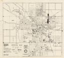
| Date: | 1908 |
|---|---|
| Description: | Colored map showing a panoramic view of Madison in great detail. The Wisconsin State Capitol is located at the center, with Lake Mendota in the background ... |

| Date: | 1872 |
|---|---|
| Description: | Birds-eye drawing of Eau Claire depicts street names and street locations, houses, trees, bridges, piers, canals, railroads, and the Chippewa and Eau Clair... |
If you didn't find the material you searched for, our Library Reference Staff can help.
Call our reference desk at 608-264-6535 or email us at: