 Search: public
Filter: Subject of church buildings
Search: public
Filter: Subject of church buildings

| Date: | |
|---|---|
| Description: | The Public Library and Congregational Church in Ladysmith. |

| Date: | 01 01 1909 |
|---|---|
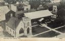
| Description: | Text on front reads: "View at Two Rivers, Wis. Washington Street Near the Public Square." Buildings on the Public Square, several with steeples. Pedestrian... |
| Date: | |
|---|---|
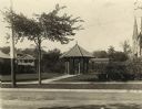
| Description: | Gazebo in Library Park behind the Watertown Public Library. The gazebo has a clay tile roof, and there are also benches, trellises, and a fountain. A churc... |

| Date: | |
|---|---|
| Description: | Panoramic picture postcard of the exterior of the Black River Falls Public Library. One side of the library has a large white stone on which is carved: "Pu... |

| Date: | 12 16 1964 |
|---|---|
| Description: | Nativity scene in front of a Christian church, with the question of the appropriateness at a public school. |

| Date: | 2004 |
|---|---|
| Description: | This map shows ATMs, houses of worship, hotels, parking ramps, public parking, union cab stands, bus stops, business district, parks and public areas, gove... |

| Date: | 1912 |
|---|---|
| Description: | View across road of a Norwegian Church, and a Public School next door. The church building features a tall steeple, lancet arched windows, gable roof, and ... |

| Date: | 1874 |
|---|---|
| Description: | Bird's-eye map of Lodi, with inset of Public School. Includes index of churches and points of interest. |
| Date: | 1945 |
|---|---|
| Description: | Elevated view of the public library and the church next door. Caption reads: "Bird's Eye View Jefferson, Wis." |
| Date: | 1874 |
|---|---|
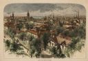
| Description: | Bird's-eye view of Milwaukee looking southwest toward the county courthouse under construction in the public square west of St. John's Cathedral. |

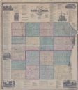
| Date: | 1863 |
|---|---|
| Description: | Includes index to public buildings, churches, schools. Inset: Glidden & Lockwood’s addition. Gives names of some property owners. |

| Date: | 1872 |
|---|---|
| Description: | Birds-eye drawing of Eau Claire depicts street names and street locations, houses, trees, bridges, piers, canals, railroads, and the Chippewa and Eau Clair... |

| Date: | 1878 |
|---|---|
| Description: | This bird’s-eye-view map of Barton is indexed for parochial and public schools, churches, a convent, the railroad depot, and the post office. |
| Date: | 1903 |
|---|---|
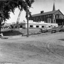
| Description: | View across unpaved road towards construction workers working on the first floor of the Eau Claire Public Library at the intersection of Farwell Street and... |

| Date: | 1916 |
|---|---|
| Description: | This map of Racine includes an indexed street directory, schools, public buildings, parks, directory of buildings, and churches. The map includes 3 illustr... |
| Date: | 1965 |
|---|---|
| Description: | This map shows Milwaukee County Parkway lands, streets, streets not yet constructed, public facilities, schools, churches, and manufacturers. The map inclu... |
| Date: | |
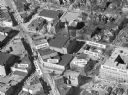
|---|---|
| Description: | Aerial view of Madison, including Yost's, State Street, The Orpheum Theatre, Hills, the Madison Public Library, block 64 parking, East Johnson Street, and ... |

| Date: | 12 1912 |
|---|---|
| Description: | Sanborn Map of Sun Prairie. The map highlights the public and parochial schools, the exhange, and church buildings, etc. |
| Date: | 1909 |
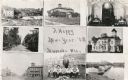
|---|---|
| Description: | Composite of views of Muscoda including: Electric Light plant, Smalley House, St. John Catholic Church, Lover's Lane, Muscoda Public School, Wisconsin Aven... |
| Date: | 1873 |
|---|---|
| Description: | This hand-colored map includes business directories, a statistical table, as well as illustrations of public, residential, and commercial properties. Commu... |
If you didn't find the material you searched for, our Library Reference Staff can help.
Call our reference desk at 608-264-6535 or email us at: