 Search: public
Filter: Subject of fortification
Search: public
Filter: Subject of fortification

| Date: | 1960 |
|---|---|
| Description: | This map is a facsimile of a 1829 map and shows private land claims, landowners within military reserve boundaries, sawmill, Fort Howard, public barns, bri... |
| Date: | |
|---|---|
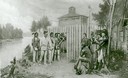
| Description: | Diorama in the Milwaukee Public Museum depicting Black Hawk's surrender on August 27, 1832 at Fort Crawford in Prairie du Chien. |

| Date: | 1900 |
|---|---|
| Description: | This map of West Navarino shows plat of the town, lots by number, local streets, public square, The Fox River, and Fort Howard. The bottom of the map reads... |

| Date: | 1835 |
|---|---|
| Description: | Map shows the Fox River, lot and block numbers, private claims, streets, a public squares, a manual labour school, and Fort Howard. An inset map shows a pl... |

| Date: | 1900 |
|---|---|
| Description: | This photostat of a manuscript map originally drawn in 1829 shows landownership, buildings, including Fort Howard and U.S. sawmill, swamps, public barns an... |

| Date: | 1862 |
|---|---|
| Description: | This map shows landownership on a military reserve, private claims, buildings (including Fort Howard and U.S. sawmill), swamps, public barns and fields, an... |

| Date: | 1814 |
|---|---|
| Description: | Fort Shelby, built by the Americans during the War of 1812. In 1814 the fort surrendered to British forces led by Captain Andrew W. Bulger who renamed it F... |
| Date: | |
|---|---|
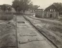
| Description: | Completed excavations at Fort Crawford showing the north row of buildings. Caption reads: "N. Row Bldgs. Completed excavations, Ft. Crawford." |

| Date: | 1776 |
|---|---|
| Description: | Fairly detailed map of New York City and parts of Long Island. It shows streets, roads, wharves, ferries, ship yards, Fort George and the battery, public b... |

| Date: | |
|---|---|
| Description: | The Fort Crawford site showing the main water trench to the swimming pool. Caption reads: "Discovery of Ft. Crawford — Water Main Trench to swimming pool p... |

| Date: | 1860 |
|---|---|
| Description: | A survey map of Wisconsin, southeastern Minnesota, and northern Iowa, showing the status of surveys, rivers, and lakes. The map also shows the locations of... |

| Date: | 1848 |
|---|---|
| Description: | Map of Wisconsin and a portion of Minnesota showing the township surveys in progress in portions of the Saint Croix River region and in central Wisconsin a... |

| Date: | 1846 |
|---|---|
| Description: | This map shows the plotting of the various townships in Wisconsin, both those that had been surveyed and some outlines for those which have not. A note in ... |
| Date: | 1823 |
|---|---|
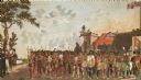
| Description: | British evacuation of their fort at Prairie du Chien after the end of the War of 1812. Fort Shelby, the first fort at Prairie du Chien, was built in 1814 b... |

| A Fortification That may not Have Existed |
|---|
| Learn the story surrounding the building of Fort Koshkonong by General Henry Atkinson. |
If you didn't find the material you searched for, our Library Reference Staff can help.
Call our reference desk at 608-264-6535 or email us at: