 Search: public
Filter: Subject of human settlements
Filter: Year of 1800-1899
Search: public
Filter: Subject of human settlements
Filter: Year of 1800-1899
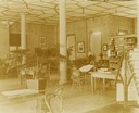
| Date: | 1896 |
|---|---|
| Description: | Interior view of the Eau Claire Public Library. Tables and bookshelves in the public library reading room. |
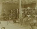
| Date: | 1896 |
|---|---|
| Description: | Bookshelves and desks within the Eau Claire Public Library Reading Room. |
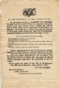
| Date: | 1838 |
|---|---|
| Description: | Broadside advertising the public sale of land at Green Bay, issued by Martin Van Buren. |
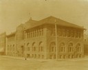
| Date: | 1896 |
|---|---|
| Description: | Corner view from intersection towards the Ingram block, which contained the public library. |
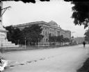
| Date: | 1898 |
|---|---|
| Description: | View across Grand Avenue of the Milwaukee Public Library. To the left, the base of the Midsummer Festival Monument can be seen, and the George Washington m... |

| Date: | 1835 |
|---|---|
| Description: | This map of Wisconsin Territory was compiled by public surveys in 1835; it is limited to modern-day southern Wisconsin. Included are two insets – one of th... |

| Date: | 01 1899 |
|---|---|
| Description: | Shows lot and block numbers, railroads, ward boundaries, and some landownership. Includes public building index. |

| Date: | 1850 |
|---|---|
| Description: | This map of Cassville shows plat of the town, roads, landings and public wharfs and the Mississippi River. |

| Date: | 1867 |
|---|---|
| Description: | Bird's-eye map of Berlin, with insets of West Side Public School and High School. |

| Date: | 1870 |
|---|---|
| Description: | Bird's-eye map of Hudson, with insets of Court House and Public School. |

| Date: | 1868 |
|---|---|
| Description: | Bird's-eye map of Portage, with insets of the Court House and the Public School. |

| Date: | 1874 |
|---|---|
| Description: | Bird's-eye map of Lodi, with inset of Public School. Includes index of churches and points of interest. |
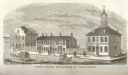
| Date: | 1815 |
|---|---|
| Description: | Engraved view of the first state buildings in Columbus, Ohio, including the United States Courthouse, Public Offices and the Old State House. A number of p... |

| Date: | 1850 |
|---|---|
| Description: | This map of Geneva shows lots and acreages, reserved land, and public squares. Streets and Lake Geneva are labeled. The map includes manuscript annotations... |
| Date: | 1874 |
|---|---|
| Description: | Bird's-eye view of Milwaukee looking southwest toward the county courthouse under construction in the public square west of St. John's Cathedral. |

| Date: | 1882 |
|---|---|
| Description: | This map is ink and watercolor on paper and shows numbered plots, the public square, streets, Lake St. Croix and the Mississippi River. |
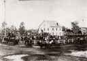
| Date: | 1870 |
|---|---|
| Description: | View of an unidentified ceremony taking place at the public square on the steps of the original Waupaca County Courthouse. |

| Date: | 1863 |
|---|---|
| Description: | Includes index to public buildings, churches, schools. Inset: Glidden & Lockwood’s addition. Gives names of some property owners. |

| Date: | 1888 |
|---|---|
| Description: | This map shows city wards, block numbers, parks, cemeteries, roads, railroads, and selected buildings. The map includes indexes to streets, public building... |

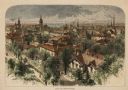
| Date: | 1872 |
|---|---|
| Description: | Birds-eye drawing of Eau Claire depicts street names and street locations, houses, trees, bridges, piers, canals, railroads, and the Chippewa and Eau Clair... |
If you didn't find the material you searched for, our Library Reference Staff can help.
Call our reference desk at 608-264-6535 or email us at: