 Search: transportation
Search: farms
Filter: Categories of Wisconsin Historical Images
Filter: Year of 1800-1899
Search: transportation
Search: farms
Filter: Categories of Wisconsin Historical Images
Filter: Year of 1800-1899

| Date: | 1876 |
|---|---|
| Description: | Map shows townships and sections, landownership and acreages, roads, railroads, post offices, and farms. Sections appear in pink, yellow, and blue. On the ... |
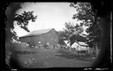
| Date: | 1873 |
|---|---|
| Description: | View of several farms, including Burton's, Fitlen's and Rustebakke's. Field arrangements and fencing patterns are evident. A man is walking along the bott... |

| Date: | 1892 |
|---|---|
| Description: | Map shows farms, schools, saw mills, townships, railroads, and roads. Counties are labelled and are outlined in yellow and pink. On the upper right and le... |

| Date: | 1855 |
|---|---|
| Description: | This map is ink, pencil, and color on paper and shows property owners, a cemetery, farms, hotels, roads, a dike and on the back are additional notes. Notes... |

| Date: | 1834 |
|---|---|
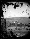
| Description: | Peck-a-ton-oka (Pecatonica River) with Rodolf farm in the background. |
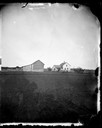
| Date: | 09 19 1876 |
|---|---|
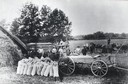
| Description: | Brenum farmstead with cattle horses and agricultural equipment in view. |

| Date: | 1897 |
|---|---|
| Description: | View down dirt road, with a few homes on each side of the lane. |

| Date: | 1878 |
|---|---|
| Description: | An etching of the farm and residence of Mrs. C.E. Packman and her son. |

| Date: | 1854 |
|---|---|
| Description: | Brightly-colored map exhaustively marks the townships, County Towns and villages of Wisconsin. It also shows rivers, canals, railroads, and plank roads. Ea... |

| Date: | 1890 |
|---|---|
| Description: | This map shows the Wisconsin Central Railroad land grant lands owned and for sale by the Soo Line in Ashland County, Wisconsin, as well as in portions of B... |
| Date: | 1890 |
|---|---|
| Description: | Sweep horsepower threshing. Men and products lined up near the machinery with a large haystack on the left. |
| Date: | 09 09 1881 |
|---|---|
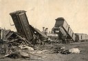
| Description: | Wreck of the Chicago, St. Paul, Minneapolis and Omaha railroad line on the Teegarten farm near Menomonie. Dead cows are in the foreground. |

| Date: | 1890 |
|---|---|
| Description: | This 1890s map shows the Wisconsin Central Railroad land grant lands owned and for sale by the Soo Line in Ashland County, Wisconsin, as well as in the eas... |

| Date: | 1890 |
|---|---|
| Description: | Bird's-eye map of West Superior and Superior, with insets of Wright Farm and First Building in Superior. |
| Date: | 1870 |
|---|---|
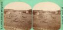
| Description: | Men, horses and wagons on a hillside. A barn and another building are in the background. |
| Date: | 1870 |
|---|---|
| Description: | A family in a wagon, on horseback and standing in front of farmstead that has a stone fence. |
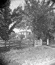
| Date: | 1874 |
|---|---|
| Description: | Brick house with well-landscaped property and unusual board fence. A.L. Dahl's photographic wagon is in the right foreground. |
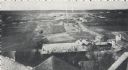
| Date: | 1870 |
|---|---|
| Description: | Elevated view from rooftops of what was known as Watertown Plank road, looking west from about North 35th Street. Several homes, and many open fields occup... |

| Date: | 1855 |
|---|---|
| Description: | Drawn seven years after Wisconsin entered statehood, this map shows the counties, cities, towns, rivers and lakes in the entire state. The map includes a c... |
If you didn't find the material you searched for, our Library Reference Staff can help.
Call our reference desk at 608-264-6535 or email us at:
