 Filter: Subject of prairies

| Date: | 1906 |
|---|---|
| Description: | Cover of an advertising catalog for Buffalo Pitts threshers sold by International Harvester. The cover features an illustration of four buffalo standing ne... |

| Date: | 1905 |
|---|---|
| Description: | View of town behind a prairie field and a lake. Caption reads: "Packwaukee, Wis." |

| Date: | |
|---|---|
| Description: | A view of a symmetrical rows of trees in an orchard on the plains. |

| Date: | 1847 |
|---|---|
| Description: | A hand-colored map that shows the area south and east of the Wisconsin and Fox Rivers, as well as a few landmarks just north of that area. The township gri... |

| Date: | 1858 |
|---|---|
| Description: | An ink on paper map of Milwaukee County and the eastern portion of Waukesha County that shows the townships of Oak Creek, Franklin, Greenfield, Wauwatosa, ... |

| Date: | 10 19 1836 |
|---|---|
| Description: | This 1836 manuscript map shows the sections, windfalls, marshes, streams, prairies, acreages, and former mouth of the Pike River in what is now the eastern... |

| Date: | 1974 |
|---|---|
| Description: | This 1974 map is a reproduction of the original survey maps of the Four Lakes region of Dane County, Wisconsin. It shows sections, lakes, rivers, wetlands,... |

| Date: | 1873 |
|---|---|
| Description: | This map shows lots and blocks, additions and subdivisions, and large-scale landownership. The map is oriented with north to the upper right. The map is fr... |

| Date: | 1832 |
|---|---|
| Description: | This map shows lot and block numbers, as well as the location of a shot tower, houses, stores, and barns. The map is oriented with the north to the left. T... |

| Date: | 1838 |
|---|---|
| Description: | This map is a development plat that shows street names, numbered blocks and lots, and small farm lot owners. Included on the right of the map is a large am... |

| Date: | 10 1776 |
|---|---|
| Description: | Broadside map showing the British invasion of New York city in August and September of 1776. The map shows important cities, forts, roads, hills, mountains... |

| Date: | 1935 |
|---|---|
| Description: | A row of trucks are parked in a lot with trees in the background. The caption identifies the trucks as belonging to CCC 2670, the Madison-based 2670th Comp... |
| Date: | 03 1953 |
|---|---|
| Description: | View across a prairie toward wooded hills. Caption reads: "Wisconsin River Valley. Bluffs as seen from Highway 80 west of Avoca, Wis." |

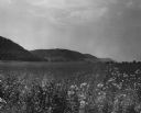
| Date: | 06 1952 |
|---|---|
| Description: | View across a prairie. Groves of trees, a herd of cattle, and a lake are in the distance. |

| Date: | 1950 |
|---|---|
| Description: | Castle Rock, surrounded by trees and a meadow. The geological feature is near Volk Field Air National Guard Base. |
If you didn't find the material you searched for, our Library Reference Staff can help.
Call our reference desk at 608-264-6535 or email us at:
