 Filter: Categories of Wisconsin Historical Images
Filter: FORMAT_TYPE of photographic print, b
Filter: Subject of botany
Filter: Subject of erosion
Filter: Categories of Wisconsin Historical Images
Filter: FORMAT_TYPE of photographic print, b
Filter: Subject of botany
Filter: Subject of erosion

| Date: | 1928 |
|---|---|
| Description: | T. N19 R. 4W about section 19, McPeak farm. A 50 foot deep ravine is seen rapidly eating its way toward farm buildings. |

| Date: | 04 1937 |
|---|---|
| Description: | From back of print: "Dane County, Town of Middleton, north 1/2 section of section 17 looking SW from a hill across the valley showing erosion and stump pas... |
| Date: | 02 1915 |
|---|---|
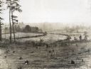
| Description: | Elevated view of a terraced farm field belonging to M.L. Jackson. Multiple tree stumps are scattered throughout the foreground and farm buildings are in th... |
| Date: | 03 18 1915 |
|---|---|
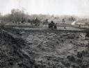
| Description: | View of an abandoned cotton field along the side of a dirt road. A farmhouse and farm buildings are in the distance. |
| Date: | 01 20 1914 |
|---|---|
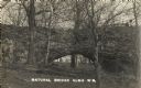
| Description: | Photographic postcard of a geological formation called "Natural Bridge" in Natural Bridge State Park. |

| Date: | 1911 |
|---|---|
| Description: | The dramatic shoreline of the Namakan River, featuring eroded land and tall trees. The canoes are on the shoreline. |

| Date: | |
|---|---|
| Description: | View of a sand cliff and beach. Trees are growing at the top of the cliff, with exposed roots from erosion. |

| Date: | 1924 |
|---|---|
| Description: | A small group is filling in part of the Archibald Lake shoreline with branches to protect the point from erosion. Names from left to right: Pete Blanchard,... |
If you didn't find the material you searched for, our Library Reference Staff can help.
Call our reference desk at 608-264-6535 or email us at:
