 Filter: Categories of Wisconsin Historical Images
Filter: FORMAT_TYPE of prints, photomechanical
Filter: Subject of fortification
Filter: Subject of cities and towns
Filter: Categories of Wisconsin Historical Images
Filter: FORMAT_TYPE of prints, photomechanical
Filter: Subject of fortification
Filter: Subject of cities and towns

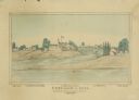
| Date: | 1876 |
|---|---|
| Description: | Elevated view showing Elmore and Kelly's Elevator with a boat, train, and the buildings at Fort Howard. Fort Howard was incorporated into Green Bay. Captio... |

| Date: | 1855 |
|---|---|
| Description: | Fox-Wisconsin portage and canal map, when the canal was not yet built. From a map in the office of the city clerk at Portage. "The old trail, the location ... |

| Date: | 1831 |
|---|---|
| Description: | Fort Winnebago, a print published in Mrs. John H. Kinzie's Wau-bun (1856). |
| Date: | |
|---|---|
| Description: | View of Chicago from Chicago River. The homes of John Dean, J. Baptiste Beaubien, Dr. Walcott, and John Kinzie are identified by number. Fort Dearborn can ... |
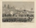
| Date: | 1864 |
|---|---|
| Description: | "Siege of Vicksburg." An etching published by Johnson, Fry & Company from a painting by Chappel of the Union lines during the battle. |

| Date: | 1820 |
|---|---|
| Description: | This map displays the plan for claiming various settlement zones in the Prairie des Chiens area in 1820. It shows Fort Crawford and 87 confirmed and unconf... |

| Date: | 1942 |
|---|---|
| Description: | These three maps depict the locations of French missions and French forts in Wisconsin, as well as the French place names in the state. |

| Date: | 1941 |
|---|---|
| Description: | This pictorial map of Wisconsin with historical text highlights the history of the state and identifies places of interest, Indian villages, missions, trad... |

| Date: | 1846 |
|---|---|
| Description: | A hand-colored map of Wisconsin shows the counties in the state south and east of the Wisconsin and Fox rivers and the locations of Indian lands to the nor... |

| Date: | 1848 |
|---|---|
| Description: | A map of the Wisconsin and Iowa territories, with the surveyed counties of southern Wisconsin and eastern Iowa identified. The map shows the sectioning of ... |

| Date: | 1850 |
|---|---|
| Description: | A hand-colored map showing portions of present-day Iron and Vilas counties north of the Manitowish River as part of the Upper Peninsula of Michigan. The Wi... |

| Date: | 1852 |
|---|---|
| Description: | A hand-colored map showing portions of present-day Iron and Vilas counties north of the Manitowish River as part of the Upper Peninsula of Michigan. The Wi... |

| Date: | 1864 |
|---|---|
| Description: | This map created during the Civil War indicates Confederate fortifications, houses, names of residents, towns, roads, railroads, relief by hachures, draina... |

| Date: | 1864 |
|---|---|
| Description: | Map of eastern Virginia and part of Maryland, showing engagements by crossed swords, fortifications surrounding Richmond, routes of the opposing armies fro... |

| Date: | 1865 |
|---|---|
| Description: | Detailed map of the southeastern United States showing fortifications, "movements of Genl. J.H. Wilson's Cavalry Corps," "pursuit of Hood" and the lines of... |

| Date: | 1862 |
|---|---|
| Description: | Map of southeastern Virginia indicating fortifications, towns, roads, railroads, drainage, and some vegetation. 2 sheets, each mounted on 1 sheet. |

| Date: | 1847 |
|---|---|
| Description: | A hand-colored map that shows the area south and east of the Wisconsin and Fox Rivers, as well as a few landmarks just north of that area. The township gri... |

| Date: | 1887 |
|---|---|
| Description: | This 1887 manuscript map by Amidon G. Miller covers portions of the towns of Nelson and Stockholm in Pepin County, Wisconsin, as well as a portion of the T... |

| Date: | 1911 |
|---|---|
| Description: | This hand-colored map is a 1911 copy of a map drawn by Gaspard-Joseph Chaussegros de Léry in 1730 showing the Fox River from its mouth at Green Bay to Lake... |

| Date: | 1887 |
|---|---|
| Description: | This etching by Amidon G. Miller covers portions of the towns of Nelson and Stockholm in Pepin County, Wisconsin, as well as a portion of the Town of Maide... |
If you didn't find the material you searched for, our Library Reference Staff can help.
Call our reference desk at 608-264-6535 or email us at: