 Filter: Categories of Wisconsin Historical Images
Filter: FORMAT_TYPE of prints, photomechanical
Filter: Subject of human settlements
Filter: Subject of wisconsin state capitol
Filter: Categories of Wisconsin Historical Images
Filter: FORMAT_TYPE of prints, photomechanical
Filter: Subject of human settlements
Filter: Subject of wisconsin state capitol

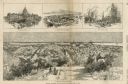
| Date: | 1908 |
|---|---|
| Description: | Colored map showing a panoramic view of Madison in great detail. The Wisconsin State Capitol is located at the center, with Lake Mendota in the background ... |
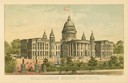
| Date: | 1891 |
|---|---|
| Description: | Chromolithograph of the third Wisconsin State Capitol with a U.S. flag atop the dome. The colored illustration was produced by the Milwaukee Lithography an... |

| Date: | 1867 |
|---|---|
| Description: | Bird's-eye map of Madison with insets of the University, Rasdall House, Vilas House, and the Wisconsin State Capitol. View includes cattail marsh, smokesta... |

| Date: | 1885 |
|---|---|
| Description: | Bird's-eye map of Madison, State Capital of Wisconsin, County Seat of Dane County, with inset of the Wisconsin State Capitol. |

| Date: | 1949 |
|---|---|
| Description: | Color bird's-eye map of the University of Wisconsin-Madison as it was midcentury, with two co-eds, several photographs of campus landmarks around edges, an... |

| Date: | |
|---|---|
| Description: | Colorized view of the Capitol Park and the replica of Centennial fountain installed in the park in 1878. The green paint is a change made in 1898. |
| Date: | |
|---|---|
| Description: | Embossed souvenir postcard decorated with gold that depicts the third Wisconsin State Capitol as it appeared, 1883-1904. The gold dome was an entirely arti... |

| Date: | 1909 |
|---|---|
| Description: | View of one of the four Prairie du Chien stone gateways that stood at the four corner entrances to the Capitol Park. More elaborate gates topped with iron ... |

| Date: | 1904 |
|---|---|
| Description: | Postcard depicting the fire of February 26-27, 1904 that destroyed most of the second Wisconsin State Capitol. The smoke and flames have been dramatically ... |

| Date: | 1855 |
|---|---|
| Description: | Part of George Harrison's "Map of the City of Madison," showing the development of the isthmus and the small size of the second Capitol (54' x 104') in com... |

| Date: | 1896 |
|---|---|
| Description: | A portion of John B. Heim's map of the Water Works System of Madison showing the size of the third Wisconsin Capitol (228' x 226') in comparison with the C... |
| Date: | 03 30 1889 |
|---|---|
| Description: | Bird's-eye view from Bascom Hill of Madison, with vignettes of the Wisconsin State Capitol, Lake Monona, and the Capitol Park. |
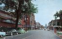
| Date: | 1950 |
|---|---|
| Description: | Color view of the State Street and Lake Street intersection, with the Co-op book store, the Rennebohm Drug Store and the Wisconsin State Capitol at the end... |
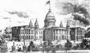
| Date: | 1889 |
|---|---|
| Description: | Illustration of the Wisconsin State Capitol with an American flag displayed on the dome. |

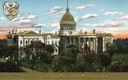
| Date: | 1900 |
|---|---|
| Description: | Colorized elevated view of the Wisconsin State Capitol. The Wisconsin State Seal is in the upper left corner. Caption reads: "State Capitol, Madison, Wisco... |

| Date: | 1929 |
|---|---|
| Description: | Photograph composite of Madison businesses including Gisholt Machine Company, French Battery and Carbon, Fuller & Johnson MFG., Oscar Mayer, Burgess Batter... |

| Date: | 1856 |
|---|---|
| Description: | Isthmus of Madison, including Lake Mendota, or Great Lake, and Lake Menona [sic]. |

| Date: | 1855 |
|---|---|
| Description: | Map of the city of Madison, Dane County, published by George Harrison, surveyed and drawn by P. McCabe, and engraved by J.H. Colton & Co., New York. In add... |
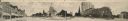
| Date: | |
|---|---|
| Description: | Panoramic view of Capitol Square, seen from the West corner. Originally functioned as an oversized post card. Identifiable businesses include Haswell Furni... |
If you didn't find the material you searched for, our Library Reference Staff can help.
Call our reference desk at 608-264-6535 or email us at:
