 Filter: Categories of Wisconsin Historical Images
Filter: FORMAT_TYPE of prints, photomechanical
Filter: Subject of islands
Filter: Subject of bridges
Filter: Categories of Wisconsin Historical Images
Filter: FORMAT_TYPE of prints, photomechanical
Filter: Subject of islands
Filter: Subject of bridges

| Date: | 09 1871 |
|---|---|
| Description: | Bird's-eye view of Peshtigo, before it was destroyed by fire on the night of October 8, 1871. |

| Date: | 1881 |
|---|---|
| Description: | Bird's-eye map of Marinette, with insets. |

| Date: | 1867 |
|---|---|
| Description: | Birds-eye drawing of Appleton, Outagamie Co., depicting street names and street layout, houses, the Fox River, the court house, jail, school houses, Lawren... |

| Date: | 1870 |
|---|---|
| Description: | Bird's-eye map of Prairie du Sac. |

| Date: | 1875 |
|---|---|
| Description: | Bird's-eye map of Black River Falls, looking southwest. |

| Date: | 1872 |
|---|---|
| Description: | Birds-eye drawing of Eau Claire depicts street names and street locations, houses, trees, bridges, piers, canals, railroads, and the Chippewa and Eau Clair... |

| Date: | 1883 |
|---|---|
| Description: | Bird's-eye map of Prairie du Sac, Wisconsin with an inset of Clifton. |

| Date: | 1883 |
|---|---|
| Description: | Bird's-eye map of Sauk City. |

| Date: | 1891 |
|---|---|
| Description: | Bird's-eye map of Stevens Point, looking east, with an inset of the Water Works. Wisconsin River in foreground with fifty-three business locations identifi... |

| Date: | 1879 |
|---|---|
| Description: | Bird's-eye map of Two Rivers. |

| Date: | 1879 |
|---|---|
| Description: | This map is a bird's-eye view of Wausau, the County Seat of Marathon County. The map features an index of points of interest. |

| Date: | 1892 |
|---|---|
| Description: | Bird's-eye view of the Columbian Exposition pavilions from the vantage point of Lake Michigan. Included is an inset of the Union Passenger Station (now Uni... |

| Date: | |
|---|---|
| Description: | Plat map of the east central part of the city. |

| Date: | 1831 |
|---|---|
| Description: | Map of the city of Louisville, Kentucky on the Ohio River showing streets and numbered lots. The Ohio River, Corn Island, and the Louisville and Portland C... |

| Date: | 05 01 1899 |
|---|---|
| Description: | Map showing the Schuylkill River with roads, ferries, and points of interest from Valley Forge to Philadelphia, Pennsylvania as it appeared during the Revo... |

| Date: | 1990 |
|---|---|
| Description: | This map shows the Minnesota Point, Wisconsin Point, Hog Island, Baker's Island, Connors Point, Blatnik Bridge, Superior Bay, Allouez Bay, the Nemadji Rive... |

| Date: | |
|---|---|
| Description: | A bathing beach on an island near a bridge, with people in the water and on the beach within an enclosed area. A canoe and rowboat are pulled up on the sho... |
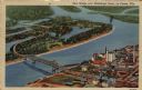
| Date: | 1951 |
|---|---|
| Description: | Aerial view of a highway bridge crossing the Mississippi River and French Island. Caption reads: "New Bridge over Mississippi River, La Crosse, Wis." |
| Date: | |
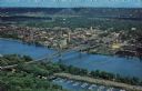
|---|---|
| Description: | Photographic postcard of an aerial view over La Crosse and the I-90 Interstate bridge. French Island is in the foreground. |
If you didn't find the material you searched for, our Library Reference Staff can help.
Call our reference desk at 608-264-6535 or email us at:
