 Filter: Categories of Wisconsin Historical Images
Filter: FORMAT_TYPE of prints, photomechanical
Filter: Subject of lakes
Filter: Subject of religion
Filter: Categories of Wisconsin Historical Images
Filter: FORMAT_TYPE of prints, photomechanical
Filter: Subject of lakes
Filter: Subject of religion
| Date: | 1945 |
|---|---|
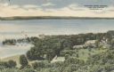
| Description: | Elevated view of American Baptist Assembly Grounds from Judson Tower. Below near the tree-covered shoreline are buildings, a recreation area, and a harbor ... |
| Date: | 1890 |
|---|---|
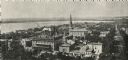
| Description: | The First Baptist Church, pictured in the lower center area of the photograph, organized in 1847 and erected in 1854. St. Raphael's Cathedral in the backgr... |
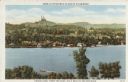
| Date: | 1910 |
|---|---|
| Description: | View from pier towards the Old Mission in La Pointe on Madeline Island. Men are sitting at the shoreline. Caption reads: "Apostle Islands, Wis. Madeline Is... |

| Date: | 1855 |
|---|---|
| Description: | Map of the city of Madison, Dane County, published by George Harrison, surveyed and drawn by P. McCabe, and engraved by J.H. Colton & Co., New York. In add... |

| Date: | 1897 |
|---|---|
| Description: | A map of Wisconsin showing the self-supporting churches, Home Missionary churches, stations not organized, Sunday schools of C.S.S. Society, Congregational... |

| Date: | 1939 |
|---|---|
| Description: | This map shows the towns to Gingles, Sanborn, and Guney as well as Chequamegon Bay, Kakagon River, White River, Marengo River, Bad River, Potato River, Vau... |

| Date: | 1881 |
|---|---|
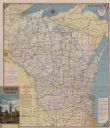
| Description: | A brochure with a map of Wisconsin that also includes information (in English, German, Norwegian, and Swedish) pertaining to the state, such as its timber ... |

| Date: | 1972 |
|---|---|
| Description: | This map of Sheboygan County, Wisconsin, shows the location of churches in the county. Churches are indexed for each town. Also shown are sections, cities ... |

| Date: | 1940 |
|---|---|
| Description: | This map of Beaver Dam pictorially shows the history of the town. The map was made for the 100th anniversary celebration of Beaver Dam in 1941. The map inc... |

| Date: | 1845 |
|---|---|
| Description: | This map shows lakes, rivers, Chippewa land, the U.S. Mineral Land Agency, boundary between U.S. and Canada, Methodist and Catholic missions, and American ... |

| Date: | 1954 |
|---|---|
| Description: | This map shows the location of Catholic churches, missions, and shrines. The map is color coded and includes a key in the bottom left corner. The back of t... |

| Date: | 1900 |
|---|---|
| Description: | This map shows landownership, churches, schools, farm houses, wagon roads, railroads, and townships and includes businesses advertisements, tables of stati... |

| Date: | 1905 |
|---|---|
| Description: | This photocopied map shows landownership, roads, railroads, rural mail routes, churches, school houses, cemeteries, and townships. The map includes adverti... |

| Date: | 2004 |
|---|---|
| Description: | This map shows ATMs, houses of worship, hotels, parking ramps, public parking, union cab stands, bus stops, business district, parks and public areas, gove... |
| Date: | |
|---|---|
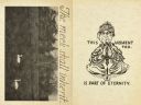
| Description: | On the left is the back of the card, with a photograph of swans on a lake surrounded by trees. The title reads: "The meek shall inherit . . ." On the right... |
| Date: | 1954 |
|---|---|
| Description: | This map is designed to help Catholic tourists in Wisconsin find Catholic churches and missions. On the front side, a road map of Wisconsin showing the loc... |

| Date: | |
|---|---|
| Description: | Watercolor reproduction, with key, of the area surrounding Holy Hill (19.) which is at top center, and below are Lake Keesus (J.) and the town of Merton (1... |
| Date: | |
|---|---|
| Description: | Elevated view across lake towards Holy Hill in the distance. Caption at top reads: "America's Favorite Place of Pilgrimage." Caption at bottom reads: "Frie... |

| Date: | |
|---|---|
| Description: | View of one end of Silver Lake. A convent is on a hill across the lake. |

| Date: | 1887 |
|---|---|
| Description: | A plat map of Waterford. Township 4, North Range 19, East of 4th Principal Meridian. References at bottom include school houses, houses, churches and cemet... |
If you didn't find the material you searched for, our Library Reference Staff can help.
Call our reference desk at 608-264-6535 or email us at: