 Filter: Categories of Wisconsin Historical Images
Filter: FORMAT_TYPE of prints, photomechanical
Filter: Subject of military art and science
Filter: Subject of indians of north america
Filter: Categories of Wisconsin Historical Images
Filter: FORMAT_TYPE of prints, photomechanical
Filter: Subject of military art and science
Filter: Subject of indians of north america

| Date: | 1835 |
|---|---|
| Description: | Little Lake Butte Des Morts just north of Lake Winnebago where Governor Lewis Cass of Michigan, and Thomas McKenney, head of the Bureau of Indian Affairs (... |
| Date: | 1832 |
|---|---|
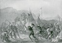
| Description: | Indians in combat at Fort McKenzie on August 28th, 1833. |
| Date: | 01 07 1855 |
|---|---|
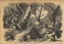
| Description: | Sketch of the defeat of General Braddock during an ambush in the French and Indian War. Caption reads: "Defeat of General Braddock, in the French and India... |
| Date: | |
|---|---|
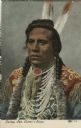
| Description: | Native American in native dress, two braids wrapped in fur, multi-strand beaded necklace. Caption reads: "Curley, Gen. Custer's Scout." |
| Date: | 1823 |
|---|---|
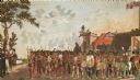
| Description: | British evacuation of their fort at Prairie du Chien after the end of the War of 1812. Fort Shelby, the first fort at Prairie du Chien, was built in 1814 b... |
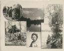
| Date: | |
|---|---|
| Description: | Composite photograph of scenes of Winnebago Indians. |
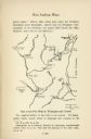
| Date: | |
|---|---|
| Description: | Hand-drawn map of the location of the Fox Indian Wars. |
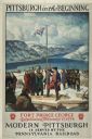
| Date: | 1930 |
|---|---|
| Description: | An original lithograph promoting Pittsburgh, Pennsylvania, and the Pennsylvania Railroad through artist N.C. Wyeth's depiction of the establishment of Fort... |
| Date: | 1860 |
|---|---|
| Description: | Illustration of the head of Louis Wigfall, on the body of an Indian with tomahawk in hand. The caption reads: "WIGFALL on his promised descent on Washingto... |

| Date: | 1942 |
|---|---|
| Description: | Holiday card with a silhouette of a soldier with his gun, walking across a map of Germany outlined in red. The word "GERMANY" is printed in gray over it. I... |

| Date: | 1941 |
|---|---|
| Description: | This pictorial map of Wisconsin with historical text highlights the history of the state and identifies places of interest, Indian villages, missions, trad... |

| Date: | 1846 |
|---|---|
| Description: | A hand-colored map of Wisconsin shows the counties in the state south and east of the Wisconsin and Fox rivers and the locations of Indian lands to the nor... |

| Date: | 1848 |
|---|---|
| Description: | Map of Wisconsin and a portion of Minnesota showing the township surveys in progress in portions of the Saint Croix River region and in central Wisconsin a... |

| Date: | 1860 |
|---|---|
| Description: | A survey map of Wisconsin, southeastern Minnesota, and northern Iowa, showing the status of surveys, rivers, and lakes. The map also shows the locations of... |
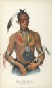
| Date: | 1849 |
|---|---|
| Description: | Hand-colored lithograph of Little Elk (Hoo-Wan-ne-ka), chief of the Ho-Chunk, as he appeared during an official visit to Washington, D.C. in 1824. This por... |

| Date: | 1847 |
|---|---|
| Description: | A hand-colored map that shows the area south and east of the Wisconsin and Fox Rivers, as well as a few landmarks just north of that area. The township gri... |
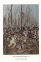
| Date: | 1982 |
|---|---|
| Description: | "The painting shows the Choctaws and a mixed group of Major Daquin's Battalion of Free Men of Color. The latter were mostly attired in civilian clothes bec... |

| Date: | |
|---|---|
| Description: | A map of southern Wisconsin and northern Illinois showing where the battles took place and routes taken by Black Hawk and his band during the Black Hawk Wa... |

| Date: | 1931 |
|---|---|
| Description: | This U.S. Geological Survey map of Wisconsin shows counties, cities and villages, lighthouses, Indian reservations, military reservations, and bird and gam... |

| Date: | 1912 |
|---|---|
| Description: | This map from the U.S. General Land Office shows railroads, counties, cities and villages, rivers, lakes, U.S. Land Offices, Indian reservations, military ... |
If you didn't find the material you searched for, our Library Reference Staff can help.
Call our reference desk at 608-264-6535 or email us at: